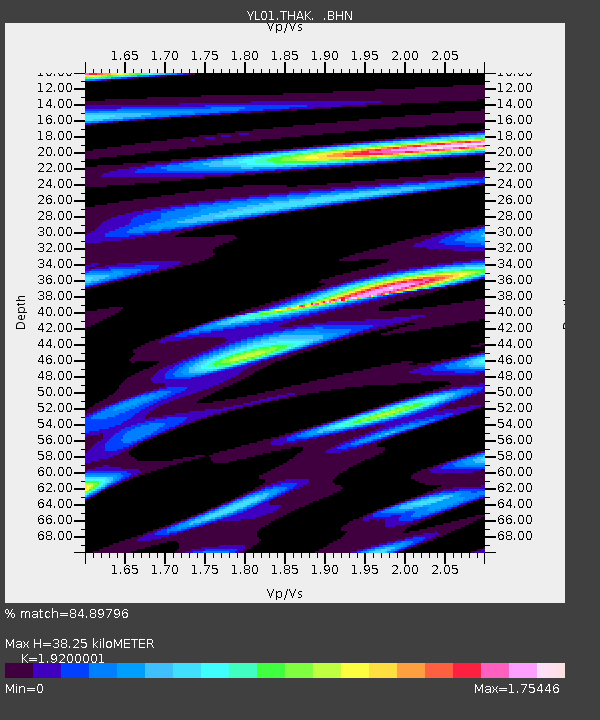
THAK YL.THAK - Earthquake Result Viewer
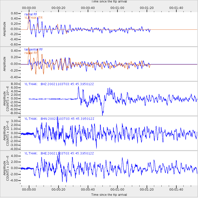
Earthquake location: Near East Coast Of Honshu, Japan
Earthquake latitude/longitude: 38.9/142.0
Earthquake time(UTC): 2002/11/03 (307) 03:37:42 GMT
Earthquake Depth: 39 km
Earthquake Magnitude: 5.7 MB, 6.1 MS, 6.4 MW, 6.4 MW
Earthquake Catalog/Contributor: WHDF/NEIC
Network: YL Himalayan Nepal Tibet Experiment
Station: THAK YL.THAK
Lat/Lon: 27.60 N/85.56 E
Elevation: 1551 m
Distance: 47.8 deg
Az: 274.083 deg
Baz: 61.303 deg
Ray Param: 0.06965338
Estimated Moho Depth: 38.25 km
Estimated Crust Vp/Vs: 1.92
Assumed Crust Vp: 6.142 km/s
Estimated Crust Vs: 3.199 km/s
Estimated Crust Poisson's Ratio: 0.31
Radial Match: 84.89796 %
Radial Bump: 400
Transverse Match: 77.33701 %
Transverse Bump: 400
SOD ConfigId: 16820
Insert Time: 2010-02-26 16:16:14.121 +0000
GWidth: 2.5
Max Bumps: 400
Tol: 0.001

Signal To Noise

ChannelStoNSTALTA
YL:THAK: :BHN:20021103T03:45:45.395012Z1.64502454.193739E-72.5493472E-7
YL:THAK: :BHE:20021103T03:45:45.395012Z7.01915749.53911E-71.3590108E-7
YL:THAK: :BHZ:20021103T03:45:45.395012Z38.5035932.0733314E-65.3847742E-8
Arrivals
Ps6.0 SECOND
PpPs17 SECOND
PsPs/PpSs23 SECOND