You are here: Home > Network List > US - United States National Seismic Network Stations List
> Station DGMT Dagmar, Montana, USA > Earthquake Result Viewer
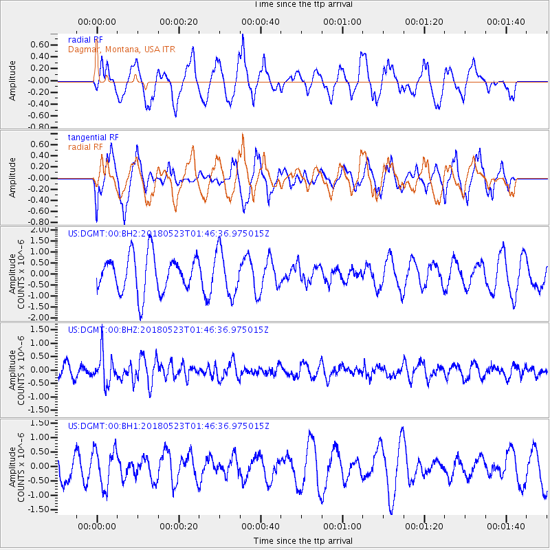
DGMT Dagmar, Montana, USA - Earthquake Result Viewer
*The percent match for this event was below the threshold and hence no stack was calculated.
| Earthquake location: |
Near East Coast Of Kamchatka |
| Earthquake latitude/longitude: |
55.3/161.9 |
| Earthquake time(UTC): |
2018/05/23 (143) 01:37:48 GMT |
| Earthquake Depth: |
59 km |
| Earthquake Magnitude: |
5.4 Mww |
| Earthquake Catalog/Contributor: |
NEIC PDE/us |
|
| Network: |
US United States National Seismic Network |
| Station: |
DGMT Dagmar, Montana, USA |
| Lat/Lon: |
48.47 N/104.20 W |
| Elevation: |
0.0 m |
|
| Distance: |
54.1 deg |
| Az: |
55.045 deg |
| Baz: |
315.186 deg |
| Ray Param: |
$rayparam |
*The percent match for this event was below the threshold and hence was not used in the summary stack. |
|
| Radial Match: |
64.30803 % |
| Radial Bump: |
400 |
| Transverse Match: |
46.16807 % |
| Transverse Bump: |
359 |
| SOD ConfigId: |
2665671 |
| Insert Time: |
2018-06-06 01:44:51.159 +0000 |
| GWidth: |
2.5 |
| Max Bumps: |
400 |
| Tol: |
0.001 |
|
Signal To Noise
| Channel | StoN | STA | LTA |
| US:DGMT:00:BHZ:20180523T01:46:36.975015Z | 2.8497355 | 5.764211E-7 | 2.0227179E-7 |
| US:DGMT:00:BH1:20180523T01:46:36.975015Z | 0.87397176 | 6.599209E-7 | 7.550826E-7 |
| US:DGMT:00:BH2:20180523T01:46:36.975015Z | 1.2242352 | 1.0286429E-6 | 8.402331E-7 |
| Arrivals |
| Ps | |
| PpPs | |
| PsPs/PpSs | |


