You are here: Home > Network List > US - United States National Seismic Network Stations List
> Station ACSO Alum Creek State Park, Ohio, USA > Earthquake Result Viewer
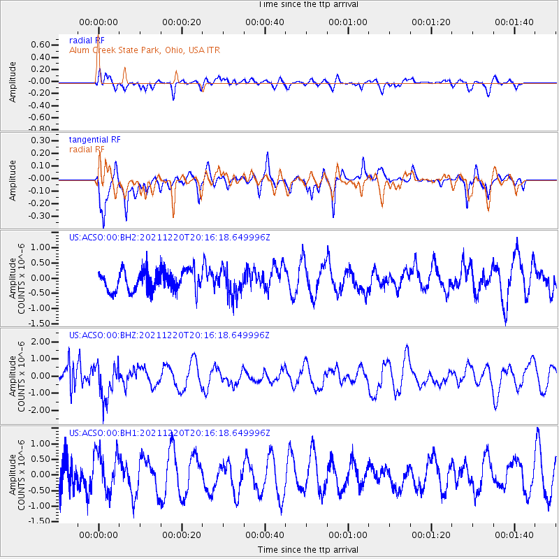
ACSO Alum Creek State Park, Ohio, USA - Earthquake Result Viewer
*The percent match for this event was below the threshold and hence no stack was calculated.
| Earthquake location: |
Near Coast Of Northern Calif. |
| Earthquake latitude/longitude: |
40.4/-124.3 |
| Earthquake time(UTC): |
2021/12/20 (354) 20:10:31 GMT |
| Earthquake Depth: |
27 km |
| Earthquake Magnitude: |
6.2 Mw |
| Earthquake Catalog/Contributor: |
NEIC PDE/nc |
|
| Network: |
US United States National Seismic Network |
| Station: |
ACSO Alum Creek State Park, Ohio, USA |
| Lat/Lon: |
40.23 N/82.98 W |
| Elevation: |
288 m |
|
| Distance: |
31.3 deg |
| Az: |
76.618 deg |
| Baz: |
283.93 deg |
| Ray Param: |
$rayparam |
*The percent match for this event was below the threshold and hence was not used in the summary stack. |
|
| Radial Match: |
67.61705 % |
| Radial Bump: |
400 |
| Transverse Match: |
74.082954 % |
| Transverse Bump: |
400 |
| SOD ConfigId: |
26694651 |
| Insert Time: |
2022-01-14 21:26:43.551 +0000 |
| GWidth: |
2.5 |
| Max Bumps: |
400 |
| Tol: |
0.001 |
|
Signal To Noise
| Channel | StoN | STA | LTA |
| US:ACSO:00:BHZ:20211220T20:16:18.649996Z | 2.147969 | 1.035045E-6 | 4.8187144E-7 |
| US:ACSO:00:BH1:20211220T20:16:18.649996Z | 0.99717426 | 6.6642065E-7 | 6.683091E-7 |
| US:ACSO:00:BH2:20211220T20:16:18.649996Z | 1.353933 | 4.640402E-7 | 3.4273498E-7 |
| Arrivals |
| Ps | |
| PpPs | |
| PsPs/PpSs | |


