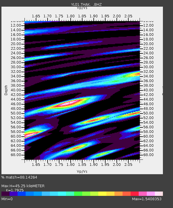
THAK YL.THAK - Earthquake Result Viewer

Earthquake location: Near N Coast Of New Guinea, P.N.G.
Earthquake latitude/longitude: -3.3/142.7
Earthquake time(UTC): 2002/09/16 (259) 13:23:00 GMT
Earthquake Depth: 10 km
Earthquake Magnitude: 5.9 MB, 5.9 MS, 6.3 MW, 6.1 MW
Earthquake Catalog/Contributor: WHDF/NEIC
Network: YL Himalayan Nepal Tibet Experiment
Station: THAK YL.THAK
Lat/Lon: 27.60 N/85.56 E
Elevation: 1551 m
Distance: 63.0 deg
Az: 303.201 deg
Baz: 109.73 deg
Ray Param: 0.05988246
Estimated Moho Depth: 45.25 km
Estimated Crust Vp/Vs: 1.79
Assumed Crust Vp: 6.142 km/s
Estimated Crust Vs: 3.426 km/s
Estimated Crust Poisson's Ratio: 0.27
Radial Match: 88.14264 %
Radial Bump: 400
Transverse Match: 82.1817 %
Transverse Bump: 400
SOD ConfigId: 16820
Insert Time: 2010-02-26 16:16:19.454 +0000
GWidth: 2.5
Max Bumps: 400
Tol: 0.001

Signal To Noise

ChannelStoNSTALTA
YL:THAK: :BHZ:20020916T13:32:56.549021Z0.83579014.537923E-85.4295008E-8
YL:THAK: :BHN:20020916T13:32:56.549021Z0.610186933.657041E-85.993312E-8
YL:THAK: :BHE:20020916T13:32:56.549021Z1.37094658.49399E-86.1957124E-8
Arrivals
Ps6.1 SECOND
PpPs20 SECOND
PsPs/PpSs26 SECOND