You are here: Home > Network List > WI - West Indies IPGP Network Stations List
> Station BIM Morne Bigot, Anses d'Arlets, Martinique > Earthquake Result Viewer
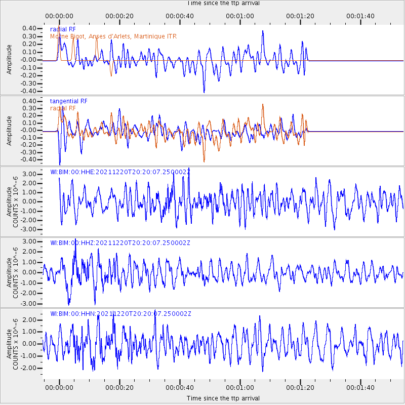
BIM Morne Bigot, Anses d'Arlets, Martinique - Earthquake Result Viewer
*The percent match for this event was below the threshold and hence no stack was calculated.
| Earthquake location: |
Near Coast Of Northern Calif. |
| Earthquake latitude/longitude: |
40.4/-124.3 |
| Earthquake time(UTC): |
2021/12/20 (354) 20:10:31 GMT |
| Earthquake Depth: |
27 km |
| Earthquake Magnitude: |
6.2 Mw |
| Earthquake Catalog/Contributor: |
NEIC PDE/nc |
|
| Network: |
WI West Indies IPGP Network |
| Station: |
BIM Morne Bigot, Anses d'Arlets, Martinique |
| Lat/Lon: |
14.52 N/61.07 W |
| Elevation: |
391 m |
|
| Distance: |
60.4 deg |
| Az: |
96.025 deg |
| Baz: |
308.344 deg |
| Ray Param: |
$rayparam |
*The percent match for this event was below the threshold and hence was not used in the summary stack. |
|
| Radial Match: |
49.16361 % |
| Radial Bump: |
400 |
| Transverse Match: |
66.14847 % |
| Transverse Bump: |
400 |
| SOD ConfigId: |
26694651 |
| Insert Time: |
2022-01-14 21:27:13.183 +0000 |
| GWidth: |
2.5 |
| Max Bumps: |
400 |
| Tol: |
0.001 |
|
Signal To Noise
| Channel | StoN | STA | LTA |
| WI:BIM:00:HHZ:20211220T20:20:07.250002Z | 2.7848878 | 1.3411064E-6 | 4.815657E-7 |
| WI:BIM:00:HHN:20211220T20:20:07.250002Z | 1.0374949 | 9.3221547E-7 | 8.9852534E-7 |
| WI:BIM:00:HHE:20211220T20:20:07.250002Z | 1.0330685 | 1.1191314E-6 | 1.083308E-6 |
| Arrivals |
| Ps | |
| PpPs | |
| PsPs/PpSs | |


