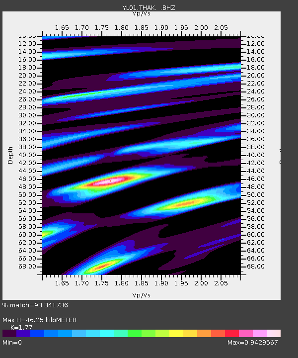
THAK YL.THAK - Earthquake Result Viewer
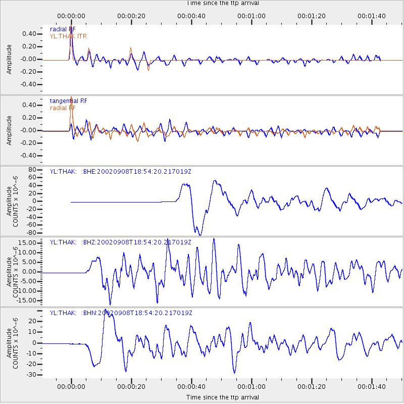
Earthquake location: Near N Coast Of New Guinea, P.N.G.
Earthquake latitude/longitude: -3.3/142.9
Earthquake time(UTC): 2002/09/08 (251) 18:44:23 GMT
Earthquake Depth: 13 km
Earthquake Magnitude: 6.5 MB, 7.8 MS, 7.6 MW, 7.3 MW
Earthquake Catalog/Contributor: WHDF/NEIC
Network: YL Himalayan Nepal Tibet Experiment
Station: THAK YL.THAK
Lat/Lon: 27.60 N/85.56 E
Elevation: 1551 m
Distance: 63.2 deg
Az: 303.107 deg
Baz: 109.557 deg
Ray Param: 0.059735883
Estimated Moho Depth: 46.25 km
Estimated Crust Vp/Vs: 1.77
Assumed Crust Vp: 6.142 km/s
Estimated Crust Vs: 3.47 km/s
Estimated Crust Poisson's Ratio: 0.27
Radial Match: 93.341736 %
Radial Bump: 400
Transverse Match: 69.990166 %
Transverse Bump: 400
SOD ConfigId: 16820
Insert Time: 2010-02-26 16:16:20.761 +0000
GWidth: 2.5
Max Bumps: 400
Tol: 0.001

Signal To Noise

ChannelStoNSTALTA
YL:THAK: :BHZ:20020908T18:54:20.217019Z1.12527431.3684584E-71.2161111E-7
YL:THAK: :BHN:20020908T18:54:20.217019Z0.982446551.5470468E-71.574688E-7
YL:THAK: :BHE:20020908T18:54:20.217019Z7.9907125.374578E-76.7260316E-8
Arrivals
Ps6.0 SECOND
PpPs20 SECOND
PsPs/PpSs26 SECOND