You are here: Home > Network List > CI - Caltech Regional Seismic Network Stations List
> Station LRL Laurel Mtn Radio Fac, Ridgecrest, CA, USA > Earthquake Result Viewer
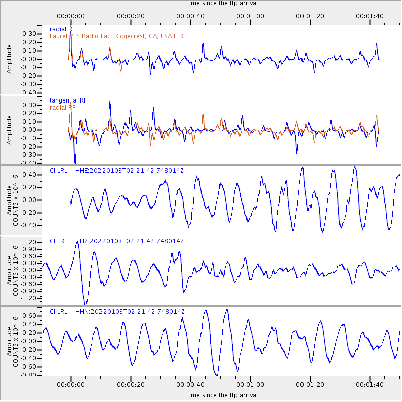
LRL Laurel Mtn Radio Fac, Ridgecrest, CA, USA - Earthquake Result Viewer
*The percent match for this event was below the threshold and hence no stack was calculated.
| Earthquake location: |
Vanuatu Islands |
| Earthquake latitude/longitude: |
-13.2/166.8 |
| Earthquake time(UTC): |
2022/01/03 (003) 02:09:44 GMT |
| Earthquake Depth: |
104 km |
| Earthquake Magnitude: |
6.0 mww |
| Earthquake Catalog/Contributor: |
NEIC PDE/us |
|
| Network: |
CI Caltech Regional Seismic Network |
| Station: |
LRL Laurel Mtn Radio Fac, Ridgecrest, CA, USA |
| Lat/Lon: |
35.48 N/117.68 W |
| Elevation: |
1340 m |
|
| Distance: |
86.1 deg |
| Az: |
52.372 deg |
| Baz: |
250.926 deg |
| Ray Param: |
$rayparam |
*The percent match for this event was below the threshold and hence was not used in the summary stack. |
|
| Radial Match: |
58.766567 % |
| Radial Bump: |
369 |
| Transverse Match: |
71.58236 % |
| Transverse Bump: |
257 |
| SOD ConfigId: |
26694651 |
| Insert Time: |
2022-01-17 02:18:33.822 +0000 |
| GWidth: |
2.5 |
| Max Bumps: |
400 |
| Tol: |
0.001 |
|
Signal To Noise
| Channel | StoN | STA | LTA |
| CI:LRL: :HHZ:20220103T02:21:42.748014Z | 5.416411 | 8.2097966E-7 | 1.5157264E-7 |
| CI:LRL: :HHN:20220103T02:21:42.748014Z | 0.41492823 | 1.16183294E-7 | 2.8000818E-7 |
| CI:LRL: :HHE:20220103T02:21:42.748014Z | 2.1347628 | 2.355899E-7 | 1.1035881E-7 |
| Arrivals |
| Ps | |
| PpPs | |
| PsPs/PpSs | |


