You are here: Home > Network List > YL01 - Himalayan Nepal Tibet Experiment Stations List
> Station THAK YL.THAK > Earthquake Result Viewer
THAK YL.THAK - Earthquake Result Viewer
| Earthquake location: |
Southern Greece |
| Earthquake latitude/longitude: |
36.6/24.3 |
| Earthquake time(UTC): |
2002/05/21 (141) 20:53:29 GMT |
| Earthquake Depth: |
97 km |
| Earthquake Magnitude: |
5.4 MB, 5.6 MD |
| Earthquake Catalog/Contributor: |
WHDF/NEIC |
|
| Network: |
YL Himalayan Nepal Tibet Experiment |
| Station: |
THAK YL.THAK |
| Lat/Lon: |
27.60 N/85.56 E |
| Elevation: |
1551 m |
|
| Distance: |
51.9 deg |
| Az: |
81.421 deg |
| Baz: |
296.324 deg |
| Ray Param: |
0.06679254 |
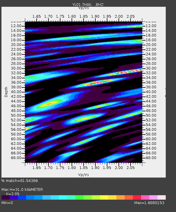
| Estimated Moho Depth: |
31.0 km |
| Estimated Crust Vp/Vs: |
2.05 |
| Assumed Crust Vp: |
6.142 km/s |
| Estimated Crust Vs: |
2.996 km/s |
| Estimated Crust Poisson's Ratio: |
0.34 |
|
| Radial Match: |
81.54386 % |
| Radial Bump: |
400 |
| Transverse Match: |
72.53232 % |
| Transverse Bump: |
400 |
| SOD ConfigId: |
16844 |
| Insert Time: |
2010-02-26 16:16:23.330 +0000 |
| GWidth: |
2.5 |
| Max Bumps: |
400 |
| Tol: |
0.001 |
|
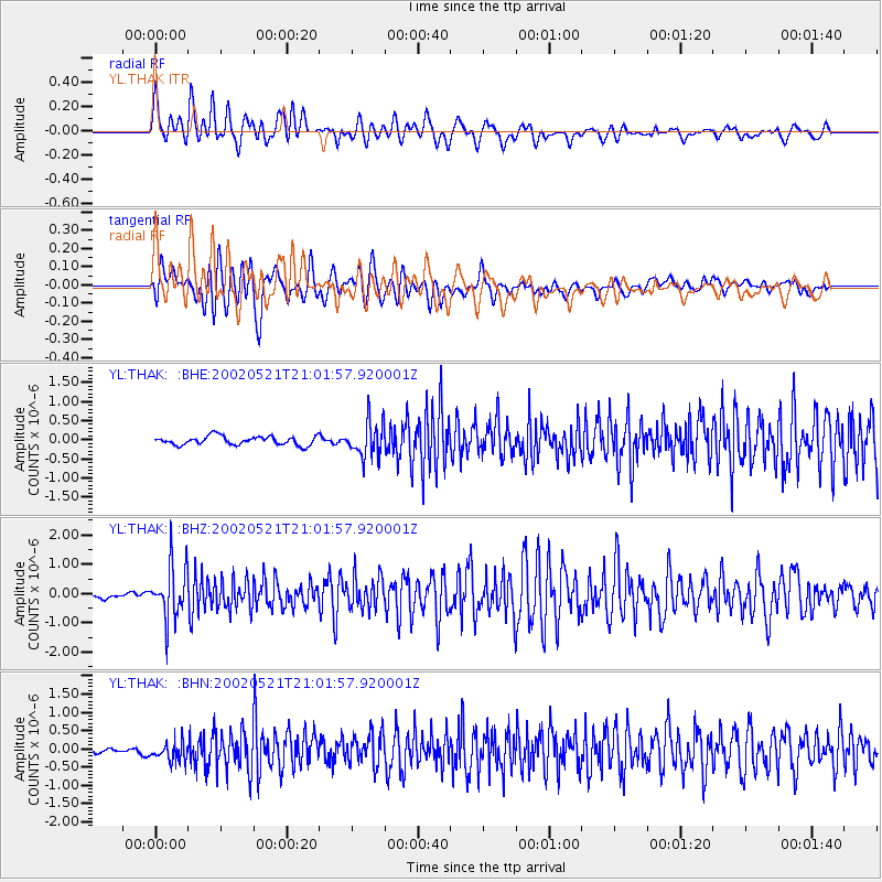
Signal To Noise
| Channel | StoN | STA | LTA |
| YL:THAK: :BHZ:20020521T21:01:57.920001Z | 9.836417 | 8.88595E-7 | 9.033727E-8 |
| YL:THAK: :BHN:20020521T21:01:57.920001Z | 3.824979 | 2.7094572E-7 | 7.083587E-8 |
| YL:THAK: :BHE:20020521T21:01:57.920001Z | 4.0025764 | 4.5492274E-7 | 1.13657485E-7 |
| Arrivals |
| Ps | 5.5 SECOND |
| PpPs | 15 SECOND |
| PsPs/PpSs | 20 SECOND |


