You are here: Home > Network List > AV - Alaska Volcano Observatory Stations List
> Station MAPS Pakushin Southeast, Makushin Volcano, Alaska > Earthquake Result Viewer
MAPS Pakushin Southeast, Makushin Volcano, Alaska - Earthquake Result Viewer
| Earthquake location: |
Taiwan Region |
| Earthquake latitude/longitude: |
24.0/122.2 |
| Earthquake time(UTC): |
2022/01/03 (003) 09:46:36 GMT |
| Earthquake Depth: |
29 km |
| Earthquake Magnitude: |
6.2 mww |
| Earthquake Catalog/Contributor: |
NEIC PDE/us |
|
| Network: |
AV Alaska Volcano Observatory |
| Station: |
MAPS Pakushin Southeast, Makushin Volcano, Alaska |
| Lat/Lon: |
53.81 N/166.94 W |
| Elevation: |
333 m |
|
| Distance: |
59.7 deg |
| Az: |
40.426 deg |
| Baz: |
269.865 deg |
| Ray Param: |
0.061937366 |
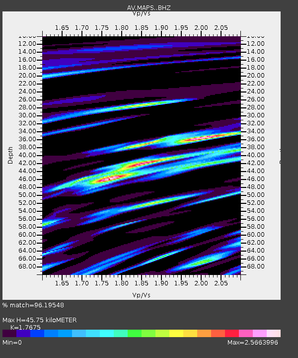
| Estimated Moho Depth: |
45.75 km |
| Estimated Crust Vp/Vs: |
1.77 |
| Assumed Crust Vp: |
3.943 km/s |
| Estimated Crust Vs: |
2.231 km/s |
| Estimated Crust Poisson's Ratio: |
0.26 |
|
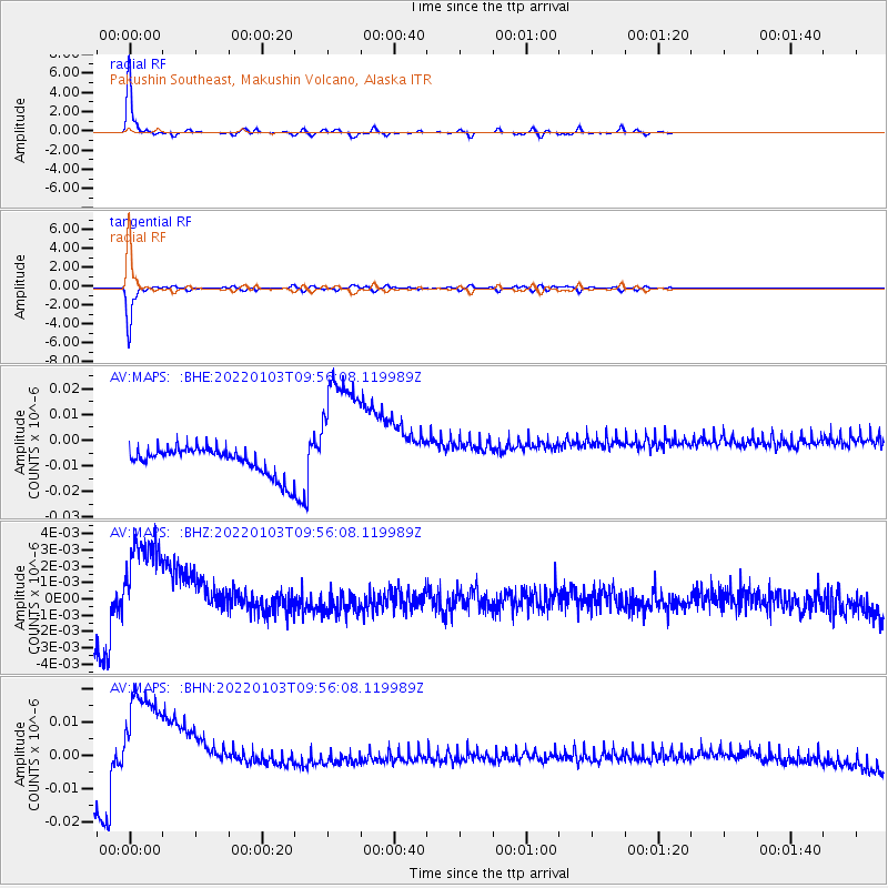
| Radial Match: |
96.19548 % |
| Radial Bump: |
232 |
| Transverse Match: |
96.608376 % |
| Transverse Bump: |
238 |
| SOD ConfigId: |
26694651 |
| Insert Time: |
2022-01-17 09:51:26.328 +0000 |
| GWidth: |
2.5 |
| Max Bumps: |
400 |
| Tol: |
0.001 |
|
Signal To Noise
| Channel | StoN | STA | LTA |
| AV:MAPS: :BHZ:20220103T09:56:08.119989Z | 4.3945775 | 3.8346926E-9 | 8.7259644E-10 |
| AV:MAPS: :BHN:20220103T09:56:08.119989Z | 4.8745003 | 2.0664826E-8 | 4.2393733E-9 |
| AV:MAPS: :BHE:20220103T09:56:08.119989Z | 4.9306006 | 2.567998E-8 | 5.2082867E-9 |
| Arrivals |
| Ps | 9.1 SECOND |
| PpPs | 32 SECOND |
| PsPs/PpSs | 41 SECOND |


