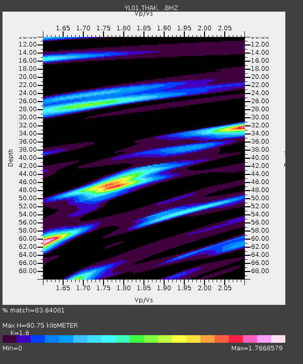
THAK YL.THAK - Earthquake Result Viewer

Earthquake location: W. Caroline Islands, Micronesia
Earthquake latitude/longitude: 11.0/140.7
Earthquake time(UTC): 2002/06/10 (161) 22:48:36 GMT
Earthquake Depth: 33 km
Earthquake Magnitude: 5.9 MB, 5.9 MS, 6.1 MW, 6.0 MW
Earthquake Catalog/Contributor: WHDF/NEIC
Network: YL Himalayan Nepal Tibet Experiment
Station: THAK YL.THAK
Lat/Lon: 27.60 N/85.56 E
Elevation: 1551 m
Distance: 54.2 deg
Az: 296.083 deg
Baz: 96.421 deg
Ray Param: 0.06555887
Estimated Moho Depth: 60.75 km
Estimated Crust Vp/Vs: 1.60
Assumed Crust Vp: 6.142 km/s
Estimated Crust Vs: 3.839 km/s
Estimated Crust Poisson's Ratio: 0.18
Radial Match: 83.64081 %
Radial Bump: 400
Transverse Match: 84.925644 %
Transverse Bump: 400
SOD ConfigId: 16844
Insert Time: 2010-02-26 16:16:26.593 +0000
GWidth: 2.5
Max Bumps: 400
Tol: 0.001

Signal To Noise

ChannelStoNSTALTA
YL:THAK: :BHZ:20020610T22:57:27.621011Z4.3294834.9525E-71.143901E-7
YL:THAK: :BHN:20020610T22:57:27.621011Z0.80861137.78692E-89.629992E-8
YL:THAK: :BHE:20020610T22:57:27.621011Z1.33542191.5405854E-71.153632E-7
Arrivals
Ps6.3 SECOND
PpPs24 SECOND
PsPs/PpSs31 SECOND