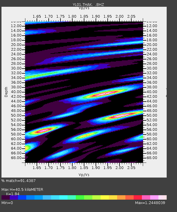
THAK YL.THAK - Earthquake Result Viewer
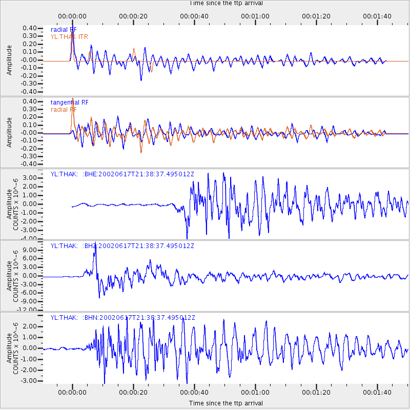
Earthquake location: Santa Cruz Islands
Earthquake latitude/longitude: -12.6/166.4
Earthquake time(UTC): 2002/06/17 (168) 21:26:22 GMT
Earthquake Depth: 33 km
Earthquake Magnitude: 6.0 MB, 6.7 MS, 6.7 MW, 6.6 MW
Earthquake Catalog/Contributor: WHDF/NEIC
Network: YL Himalayan Nepal Tibet Experiment
Station: THAK YL.THAK
Lat/Lon: 27.60 N/85.56 E
Elevation: 1551 m
Distance: 87.8 deg
Az: 298.745 deg
Baz: 105.317 deg
Ray Param: 0.043014325
Estimated Moho Depth: 40.5 km
Estimated Crust Vp/Vs: 1.94
Assumed Crust Vp: 6.142 km/s
Estimated Crust Vs: 3.166 km/s
Estimated Crust Poisson's Ratio: 0.32
Radial Match: 91.4387 %
Radial Bump: 400
Transverse Match: 93.115616 %
Transverse Bump: 400
SOD ConfigId: 16844
Insert Time: 2010-02-26 16:16:27.445 +0000
GWidth: 2.5
Max Bumps: 400
Tol: 0.001

Signal To Noise

ChannelStoNSTALTA
YL:THAK: :BHZ:20020617T21:38:37.495012Z6.2222628.150636E-71.3099152E-7
YL:THAK: :BHN:20020617T21:38:37.495012Z0.955264757.639421E-87.997177E-8
YL:THAK: :BHE:20020617T21:38:37.495012Z3.03587082.6716856E-78.800392E-8
Arrivals
Ps6.3 SECOND
PpPs19 SECOND
PsPs/PpSs25 SECOND