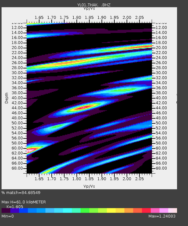
THAK YL.THAK - Earthquake Result Viewer
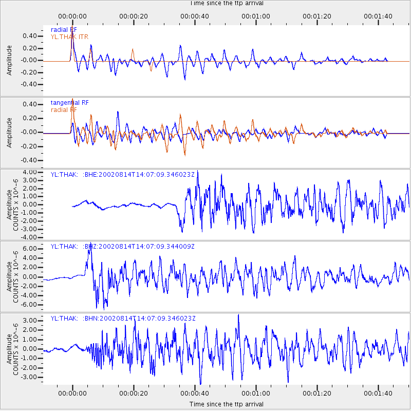
Earthquake location: Mariana Islands
Earthquake latitude/longitude: 14.1/146.2
Earthquake time(UTC): 2002/08/14 (226) 13:57:52 GMT
Earthquake Depth: 30 km
Earthquake Magnitude: 6.1 MB, 6.4 MS, 6.5 MW, 6.4 MW
Earthquake Catalog/Contributor: WHDF/NEIC
Network: YL Himalayan Nepal Tibet Experiment
Station: THAK YL.THAK
Lat/Lon: 27.60 N/85.56 E
Elevation: 1551 m
Distance: 57.7 deg
Az: 293.84 deg
Baz: 90.295 deg
Ray Param: 0.06324776
Estimated Moho Depth: 61.0 km
Estimated Crust Vp/Vs: 1.61
Assumed Crust Vp: 6.142 km/s
Estimated Crust Vs: 3.827 km/s
Estimated Crust Poisson's Ratio: 0.18
Radial Match: 84.68549 %
Radial Bump: 400
Transverse Match: 81.60852 %
Transverse Bump: 400
SOD ConfigId: 16844
Insert Time: 2010-02-26 16:16:29.835 +0000
GWidth: 2.5
Max Bumps: 400
Tol: 0.001

Signal To Noise

ChannelStoNSTALTA
YL:THAK: :BHZ:20020814T14:07:09.344009Z2.2819361.0243272E-64.4888517E-7
YL:THAK: :BHN:20020814T14:07:09.346023Z2.29353363.3016215E-71.439535E-7
YL:THAK: :BHE:20020814T14:07:09.346023Z1.56095053.828959E-72.4529663E-7
Arrivals
Ps6.3 SECOND
PpPs25 SECOND
PsPs/PpSs31 SECOND