You are here: Home > Network List > CI - Caltech Regional Seismic Network Stations List
> Station MPP McPhearson Peak > Earthquake Result Viewer
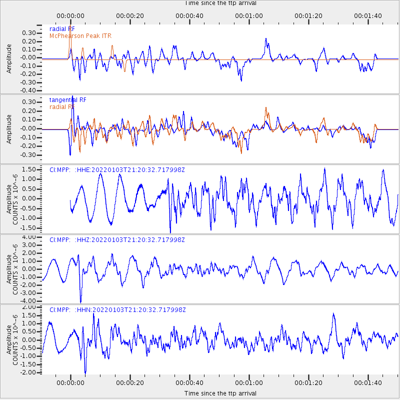
MPP McPhearson Peak - Earthquake Result Viewer
*The percent match for this event was below the threshold and hence no stack was calculated.
| Earthquake location: |
Bonin Islands, Japan Region |
| Earthquake latitude/longitude: |
27.1/141.6 |
| Earthquake time(UTC): |
2022/01/03 (003) 21:08:51 GMT |
| Earthquake Depth: |
43 km |
| Earthquake Magnitude: |
5.8 Mww |
| Earthquake Catalog/Contributor: |
NEIC PDE/us |
|
| Network: |
CI Caltech Regional Seismic Network |
| Station: |
MPP McPhearson Peak |
| Lat/Lon: |
34.89 N/119.81 W |
| Elevation: |
1739 m |
|
| Distance: |
81.4 deg |
| Az: |
55.278 deg |
| Baz: |
297.008 deg |
| Ray Param: |
$rayparam |
*The percent match for this event was below the threshold and hence was not used in the summary stack. |
|
| Radial Match: |
66.43303 % |
| Radial Bump: |
400 |
| Transverse Match: |
45.811947 % |
| Transverse Bump: |
400 |
| SOD ConfigId: |
26694651 |
| Insert Time: |
2022-01-17 21:19:24.087 +0000 |
| GWidth: |
2.5 |
| Max Bumps: |
400 |
| Tol: |
0.001 |
|
Signal To Noise
| Channel | StoN | STA | LTA |
| CI:MPP: :HHZ:20220103T21:20:32.717998Z | 2.231913 | 1.5441362E-6 | 6.9184426E-7 |
| CI:MPP: :HHN:20220103T21:20:32.717998Z | 0.733906 | 5.9835276E-7 | 8.1529896E-7 |
| CI:MPP: :HHE:20220103T21:20:32.717998Z | 0.832185 | 5.898361E-7 | 7.0878E-7 |
| Arrivals |
| Ps | |
| PpPs | |
| PsPs/PpSs | |


