You are here: Home > Network List > GT - Global Telemetered Seismograph Network (USAF/USGS) Stations List
> Station LPAZ La Paz , Bolivia > Earthquake Result Viewer
LPAZ La Paz , Bolivia - Earthquake Result Viewer
| Earthquake location: |
Central Mid-Atlantic Ridge |
| Earthquake latitude/longitude: |
7.4/-36.2 |
| Earthquake time(UTC): |
2018/05/23 (143) 05:44:43 GMT |
| Earthquake Depth: |
10 km |
| Earthquake Magnitude: |
5.5 Mww |
| Earthquake Catalog/Contributor: |
NEIC PDE/us |
|
| Network: |
GT Global Telemetered Seismograph Network (USAF/USGS) |
| Station: |
LPAZ La Paz , Bolivia |
| Lat/Lon: |
16.17 S/68.08 W |
| Elevation: |
4817 m |
|
| Distance: |
39.3 deg |
| Az: |
233.241 deg |
| Baz: |
55.781 deg |
| Ray Param: |
0.07507206 |
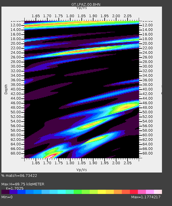
| Estimated Moho Depth: |
69.75 km |
| Estimated Crust Vp/Vs: |
1.70 |
| Assumed Crust Vp: |
6.454 km/s |
| Estimated Crust Vs: |
3.791 km/s |
| Estimated Crust Poisson's Ratio: |
0.24 |
|
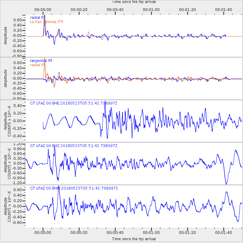
| Radial Match: |
86.73422 % |
| Radial Bump: |
349 |
| Transverse Match: |
63.66473 % |
| Transverse Bump: |
400 |
| SOD ConfigId: |
2665671 |
| Insert Time: |
2018-06-06 05:47:41.661 +0000 |
| GWidth: |
2.5 |
| Max Bumps: |
400 |
| Tol: |
0.001 |
|
Signal To Noise
| Channel | StoN | STA | LTA |
| GT:LPAZ:00:BHZ:20180523T05:51:42.798997Z | 1.7062137 | 2.8976572E-7 | 1.6982968E-7 |
| GT:LPAZ:00:BHN:20180523T05:51:42.798997Z | 0.95332575 | 7.68577E-8 | 8.062061E-8 |
| GT:LPAZ:00:BHE:20180523T05:51:42.798997Z | 1.4038118 | 1.4555329E-7 | 1.0368433E-7 |
| Arrivals |
| Ps | 8.2 SECOND |
| PpPs | 27 SECOND |
| PsPs/PpSs | 35 SECOND |


