You are here: Home > Network List > TX - Texas Seismological Network Stations List
> Station PB08 Permian Basin 08 > Earthquake Result Viewer
PB08 Permian Basin 08 - Earthquake Result Viewer
| Earthquake location: |
Bonin Islands, Japan Region |
| Earthquake latitude/longitude: |
27.1/141.6 |
| Earthquake time(UTC): |
2022/01/03 (003) 21:08:51 GMT |
| Earthquake Depth: |
43 km |
| Earthquake Magnitude: |
5.8 Mww |
| Earthquake Catalog/Contributor: |
NEIC PDE/us |
|
| Network: |
TX Texas Seismological Network |
| Station: |
PB08 Permian Basin 08 |
| Lat/Lon: |
30.89 N/102.91 W |
| Elevation: |
926 m |
|
| Distance: |
95.6 deg |
| Az: |
51.219 deg |
| Baz: |
306.094 deg |
| Ray Param: |
0.04071724 |
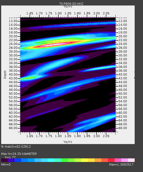
| Estimated Moho Depth: |
24.25 km |
| Estimated Crust Vp/Vs: |
1.77 |
| Assumed Crust Vp: |
6.121 km/s |
| Estimated Crust Vs: |
3.458 km/s |
| Estimated Crust Poisson's Ratio: |
0.27 |
|
| Radial Match: |
82.02912 % |
| Radial Bump: |
400 |
| Transverse Match: |
66.16748 % |
| Transverse Bump: |
189 |
| SOD ConfigId: |
26694651 |
| Insert Time: |
2022-01-17 21:30:30.078 +0000 |
| GWidth: |
2.5 |
| Max Bumps: |
400 |
| Tol: |
0.001 |
|

Signal To Noise
| Channel | StoN | STA | LTA |
| TX:PB08:00:HHZ:20220103T21:21:40.75999Z | 1.8087589 | 1.5247804E-6 | 8.4299813E-7 |
| TX:PB08:00:HH1:20220103T21:21:40.75999Z | 2.470762 | 1.1916771E-6 | 4.823116E-7 |
| TX:PB08:00:HH2:20220103T21:21:40.75999Z | 0.43884334 | 2.6804912E-7 | 6.1080823E-7 |
| Arrivals |
| Ps | 3.1 SECOND |
| PpPs | 11 SECOND |
| PsPs/PpSs | 14 SECOND |


