You are here: Home > Network List > US - United States National Seismic Network Stations List
> Station HLID Hailey, Idaho, USA > Earthquake Result Viewer
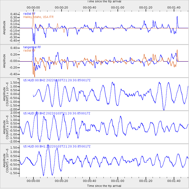
HLID Hailey, Idaho, USA - Earthquake Result Viewer
*The percent match for this event was below the threshold and hence no stack was calculated.
| Earthquake location: |
Bonin Islands, Japan Region |
| Earthquake latitude/longitude: |
27.1/141.6 |
| Earthquake time(UTC): |
2022/01/03 (003) 21:08:51 GMT |
| Earthquake Depth: |
43 km |
| Earthquake Magnitude: |
5.8 Mww |
| Earthquake Catalog/Contributor: |
NEIC PDE/us |
|
| Network: |
US United States National Seismic Network |
| Station: |
HLID Hailey, Idaho, USA |
| Lat/Lon: |
43.56 N/114.41 W |
| Elevation: |
1772 m |
|
| Distance: |
81.1 deg |
| Az: |
45.553 deg |
| Baz: |
298.941 deg |
| Ray Param: |
$rayparam |
*The percent match for this event was below the threshold and hence was not used in the summary stack. |
|
| Radial Match: |
67.91765 % |
| Radial Bump: |
388 |
| Transverse Match: |
54.488182 % |
| Transverse Bump: |
400 |
| SOD ConfigId: |
26694651 |
| Insert Time: |
2022-01-17 21:31:34.475 +0000 |
| GWidth: |
2.5 |
| Max Bumps: |
400 |
| Tol: |
0.001 |
|
Signal To Noise
| Channel | StoN | STA | LTA |
| US:HLID:00:BHZ:20220103T21:20:30.850017Z | 2.9463603 | 1.4706226E-6 | 4.9913194E-7 |
| US:HLID:00:BH1:20220103T21:20:30.850017Z | 1.487619 | 5.8974297E-7 | 3.9643416E-7 |
| US:HLID:00:BH2:20220103T21:20:30.850017Z | 0.56768996 | 5.0703875E-7 | 8.9316137E-7 |
| Arrivals |
| Ps | |
| PpPs | |
| PsPs/PpSs | |


