You are here: Home > Network List > XE05 - Sierra Nevada EarthScope Project- EarthScope Flex Array Stations List
> Station SNP37 SNP37 > Earthquake Result Viewer
SNP37 SNP37 - Earthquake Result Viewer
| Earthquake location: |
Near S. Coast Of Honshu, Japan |
| Earthquake latitude/longitude: |
35.5/140.0 |
| Earthquake time(UTC): |
2005/07/23 (204) 07:34:56 GMT |
| Earthquake Depth: |
61 km |
| Earthquake Magnitude: |
6.1 MB, 6.0 MW, 6.0 MW |
| Earthquake Catalog/Contributor: |
WHDF/NEIC |
|
| Network: |
XE Sierra Nevada EarthScope Project- EarthScope Flex Array |
| Station: |
SNP37 SNP37 |
| Lat/Lon: |
37.82 N/118.55 W |
| Elevation: |
1939 m |
|
| Distance: |
77.0 deg |
| Az: |
52.793 deg |
| Baz: |
304.855 deg |
| Ray Param: |
0.050476264 |
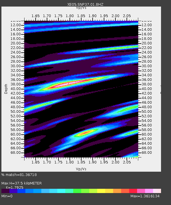
| Estimated Moho Depth: |
37.5 km |
| Estimated Crust Vp/Vs: |
1.79 |
| Assumed Crust Vp: |
6.291 km/s |
| Estimated Crust Vs: |
3.51 km/s |
| Estimated Crust Poisson's Ratio: |
0.27 |
|
| Radial Match: |
81.36718 % |
| Radial Bump: |
400 |
| Transverse Match: |
78.2961 % |
| Transverse Bump: |
400 |
| SOD ConfigId: |
268666 |
| Insert Time: |
2010-03-09 15:31:06.666 +0000 |
| GWidth: |
2.5 |
| Max Bumps: |
400 |
| Tol: |
0.001 |
|

Signal To Noise
| Channel | StoN | STA | LTA |
| XE:SNP37:01:BHZ:20050723T07:46:12.215007Z | 7.016925 | 5.959357E-7 | 8.492833E-8 |
| XE:SNP37:01:BHN:20050723T07:46:12.215007Z | 1.6133801 | 1.2003925E-7 | 7.440233E-8 |
| XE:SNP37:01:BHE:20050723T07:46:12.215007Z | 3.695667 | 2.4206875E-7 | 6.5500686E-8 |
| Arrivals |
| Ps | 4.9 SECOND |
| PpPs | 16 SECOND |
| PsPs/PpSs | 21 SECOND |


