You are here: Home > Network List > UW - Pacific Northwest Regional Seismic Network Stations List
> Station HOOD Mt Hood Meadows, OR CREST BB SMO > Earthquake Result Viewer
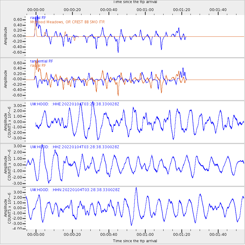
HOOD Mt Hood Meadows, OR CREST BB SMO - Earthquake Result Viewer
*The percent match for this event was below the threshold and hence no stack was calculated.
| Earthquake location: |
Northern Mid-Atlantic Ridge |
| Earthquake latitude/longitude: |
35.2/-35.2 |
| Earthquake time(UTC): |
2022/01/04 (004) 03:18:37 GMT |
| Earthquake Depth: |
10 km |
| Earthquake Magnitude: |
6.0 mww |
| Earthquake Catalog/Contributor: |
NEIC PDE/us |
|
| Network: |
UW Pacific Northwest Regional Seismic Network |
| Station: |
HOOD Mt Hood Meadows, OR CREST BB SMO |
| Lat/Lon: |
45.32 N/121.65 W |
| Elevation: |
1520 m |
|
| Distance: |
63.7 deg |
| Az: |
308.237 deg |
| Baz: |
65.695 deg |
| Ray Param: |
$rayparam |
*The percent match for this event was below the threshold and hence was not used in the summary stack. |
|
| Radial Match: |
60.979836 % |
| Radial Bump: |
400 |
| Transverse Match: |
66.29538 % |
| Transverse Bump: |
400 |
| SOD ConfigId: |
26694651 |
| Insert Time: |
2022-01-18 03:42:30.990 +0000 |
| GWidth: |
2.5 |
| Max Bumps: |
400 |
| Tol: |
0.001 |
|
Signal To Noise
| Channel | StoN | STA | LTA |
| UW:HOOD: :HHZ:20220104T03:28:38.330028Z | 7.330541 | 2.0349003E-6 | 2.775921E-7 |
| UW:HOOD: :HHN:20220104T03:28:38.330028Z | 1.8750187 | 1.6992989E-6 | 9.062837E-7 |
| UW:HOOD: :HHE:20220104T03:28:38.330028Z | 1.827825 | 2.2497318E-6 | 1.2308246E-6 |
| Arrivals |
| Ps | |
| PpPs | |
| PsPs/PpSs | |


