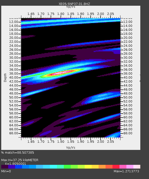
SNP37 SNP37 - Earthquake Result Viewer

Earthquake location: Near East Coast Of Honshu, Japan
Earthquake latitude/longitude: 38.1/142.1
Earthquake time(UTC): 2005/12/02 (336) 13:13:09 GMT
Earthquake Depth: 29 km
Earthquake Magnitude: 6.1 MB, 6.3 MS, 6.5 MW, 6.4 MW
Earthquake Catalog/Contributor: WHDF/NEIC
Network: XE Sierra Nevada EarthScope Project- EarthScope Flex Array
Station: SNP37 SNP37
Lat/Lon: 37.82 N/118.55 W
Elevation: 1939 m
Distance: 74.1 deg
Az: 54.343 deg
Baz: 305.949 deg
Ray Param: 0.052512843
Estimated Moho Depth: 37.25 km
Estimated Crust Vp/Vs: 1.81
Assumed Crust Vp: 6.291 km/s
Estimated Crust Vs: 3.485 km/s
Estimated Crust Poisson's Ratio: 0.28
Radial Match: 88.507385 %
Radial Bump: 400
Transverse Match: 69.66422 %
Transverse Bump: 400
SOD ConfigId: 268666
Insert Time: 2010-03-09 15:31:28.649 +0000
GWidth: 2.5
Max Bumps: 400
Tol: 0.001

Signal To Noise

ChannelStoNSTALTA
XE:SNP37:01:BHZ:20051202T13:24:11.91502Z3.97475223.779172E-79.5079436E-8
XE:SNP37:01:BHN:20051202T13:24:11.91502Z0.863382761.9103933E-72.2126842E-7
XE:SNP37:01:BHE:20051202T13:24:11.91502Z0.66240611.1720089E-71.7693209E-7
Arrivals
Ps4.9 SECOND
PpPs16 SECOND
PsPs/PpSs21 SECOND