You are here: Home > Network List > YL01 - Himalayan Nepal Tibet Experiment Stations List
> Station THAK YL.THAK > Earthquake Result Viewer
THAK YL.THAK - Earthquake Result Viewer

| Earthquake location: |
Hokkaido, Japan Region |
| Earthquake latitude/longitude: |
41.2/142.2 |
| Earthquake time(UTC): |
2002/10/14 (287) 14:12:43 GMT |
| Earthquake Depth: |
61 km |
| Earthquake Magnitude: |
5.9 MB, 6.1 MW, 6.1 MW |
| Earthquake Catalog/Contributor: |
WHDF/NEIC |
|
| Network: |
YL Himalayan Nepal Tibet Experiment |
| Station: |
THAK YL.THAK |
| Lat/Lon: |
27.60 N/85.56 E |
| Elevation: |
1551 m |
|
| Distance: |
47.9 deg |
| Az: |
272.183 deg |
| Baz: |
58.211 deg |
| Ray Param: |
0.06951539 |
| Estimated Moho Depth: |
10.0 km |
| Estimated Crust Vp/Vs: |
1.60 |
| Assumed Crust Vp: |
6.142 km/s |
| Estimated Crust Vs: |
3.839 km/s |
| Estimated Crust Poisson's Ratio: |
0.18 |
|
| Radial Match: |
87.754265 % |
| Radial Bump: |
400 |
| Transverse Match: |
81.36889 % |
| Transverse Bump: |
400 |
| SOD ConfigId: |
16844 |
| Insert Time: |
2010-02-26 16:16:42.030 +0000 |
| GWidth: |
2.5 |
| Max Bumps: |
400 |
| Tol: |
0.001 |
|
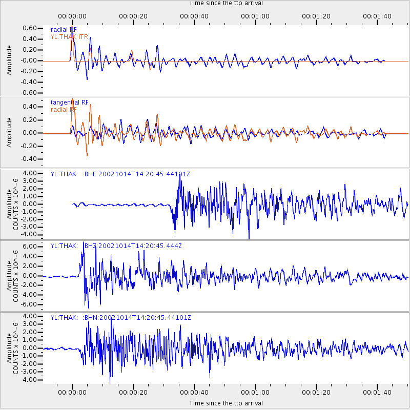
Signal To Noise
| Channel | StoN | STA | LTA |
| YL:THAK: :BHZ:20021014T14:20:45.444Z | 24.178865 | 2.4381588E-6 | 1.0083843E-7 |
| YL:THAK: :BHN:20021014T14:20:45.44101Z | 11.685218 | 7.50053E-7 | 6.418819E-8 |
| YL:THAK: :BHE:20021014T14:20:45.44101Z | 12.009844 | 1.2164747E-6 | 1.012898E-7 |
| Arrivals |
| Ps | 1.0 SECOND |
| PpPs | 4.0 SECOND |
| PsPs/PpSs | 5.0 SECOND |


