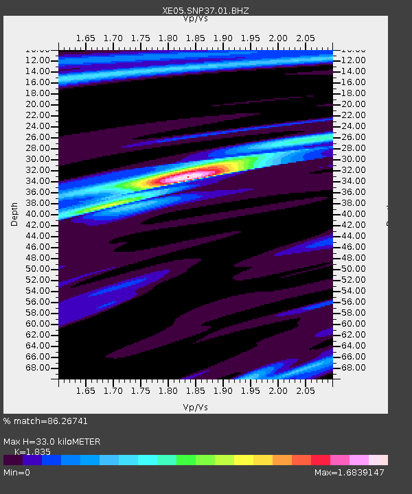
SNP37 SNP37 - Earthquake Result Viewer

Earthquake location: Near West Coast Of Colombia
Earthquake latitude/longitude: 6.9/-77.8
Earthquake time(UTC): 2006/01/23 (023) 20:50:44 GMT
Earthquake Depth: 14 km
Earthquake Magnitude: 6.1 MB, 5.9 MS, 6.2 MW, 6.1 MW
Earthquake Catalog/Contributor: WHDF/NEIC
Network: XE Sierra Nevada EarthScope Project- EarthScope Flex Array
Station: SNP37 SNP37
Lat/Lon: 37.82 N/118.55 W
Elevation: 1939 m
Distance: 48.1 deg
Az: 315.982 deg
Baz: 119.4 deg
Ray Param: 0.06958098
Estimated Moho Depth: 33.0 km
Estimated Crust Vp/Vs: 1.84
Assumed Crust Vp: 6.291 km/s
Estimated Crust Vs: 3.428 km/s
Estimated Crust Poisson's Ratio: 0.29
Radial Match: 86.26741 %
Radial Bump: 341
Transverse Match: 55.026833 %
Transverse Bump: 400
SOD ConfigId: 268666
Insert Time: 2010-03-09 15:31:33.772 +0000
GWidth: 2.5
Max Bumps: 400
Tol: 0.001

Signal To Noise

ChannelStoNSTALTA
XE:SNP37:01:BHZ:20060123T20:58:52.99001Z4.371518.106318E-71.8543518E-7
XE:SNP37:01:BHN:20060123T20:58:52.99001Z1.63647034.107656E-72.5100707E-7
XE:SNP37:01:BHE:20060123T20:58:52.99001Z1.21043062.5046765E-72.0692441E-7
Arrivals
Ps4.6 SECOND
PpPs14 SECOND
PsPs/PpSs19 SECOND