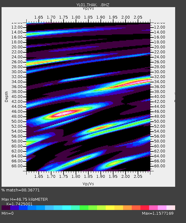
THAK YL.THAK - Earthquake Result Viewer
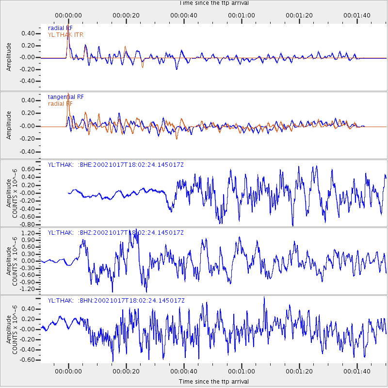
Earthquake location: Irian Jaya, Indonesia
Earthquake latitude/longitude: -3.6/140.2
Earthquake time(UTC): 2002/10/17 (290) 17:52:44 GMT
Earthquake Depth: 33 km
Earthquake Magnitude: 5.6 MB, 6.2 MS, 6.3 MW, 6.3 MW
Earthquake Catalog/Contributor: WHDF/NEIC
Network: YL Himalayan Nepal Tibet Experiment
Station: THAK YL.THAK
Lat/Lon: 27.60 N/85.56 E
Elevation: 1551 m
Distance: 61.1 deg
Az: 304.194 deg
Baz: 111.534 deg
Ray Param: 0.061048027
Estimated Moho Depth: 46.75 km
Estimated Crust Vp/Vs: 1.74
Assumed Crust Vp: 6.142 km/s
Estimated Crust Vs: 3.525 km/s
Estimated Crust Poisson's Ratio: 0.25
Radial Match: 88.36771 %
Radial Bump: 400
Transverse Match: 71.991776 %
Transverse Bump: 400
SOD ConfigId: 16844
Insert Time: 2010-02-26 16:16:45.083 +0000
GWidth: 2.5
Max Bumps: 400
Tol: 0.001

Signal To Noise

ChannelStoNSTALTA
YL:THAK: :BHZ:20021017T18:02:24.145017Z7.43633173.1513207E-74.2377355E-8
YL:THAK: :BHN:20021017T18:02:24.145017Z2.29090831.2957177E-75.655913E-8
YL:THAK: :BHE:20021017T18:02:24.145017Z1.9213921.2378464E-76.442446E-8
Arrivals
Ps5.9 SECOND
PpPs20 SECOND
PsPs/PpSs26 SECOND