You are here: Home > Network List > US - United States National Seismic Network Stations List
> Station MSO Missoula, Montana, USA > Earthquake Result Viewer
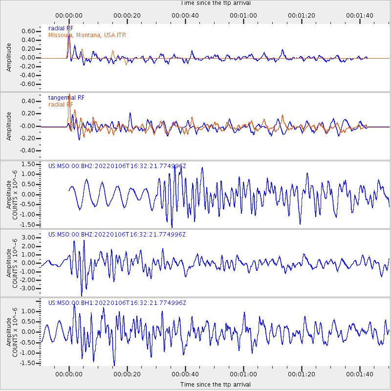
MSO Missoula, Montana, USA - Earthquake Result Viewer
*The percent match for this event was below the threshold and hence no stack was calculated.
| Earthquake location: |
Near Coast Of Nicaragua |
| Earthquake latitude/longitude: |
12.0/-87.1 |
| Earthquake time(UTC): |
2022/01/06 (006) 16:25:07 GMT |
| Earthquake Depth: |
22 km |
| Earthquake Magnitude: |
6.1 mww |
| Earthquake Catalog/Contributor: |
NEIC PDE/us |
|
| Network: |
US United States National Seismic Network |
| Station: |
MSO Missoula, Montana, USA |
| Lat/Lon: |
46.83 N/113.94 W |
| Elevation: |
1264 m |
|
| Distance: |
41.5 deg |
| Az: |
332.097 deg |
| Baz: |
138.169 deg |
| Ray Param: |
$rayparam |
*The percent match for this event was below the threshold and hence was not used in the summary stack. |
|
| Radial Match: |
70.208405 % |
| Radial Bump: |
400 |
| Transverse Match: |
69.40637 % |
| Transverse Bump: |
400 |
| SOD ConfigId: |
26694651 |
| Insert Time: |
2022-01-20 16:49:23.373 +0000 |
| GWidth: |
2.5 |
| Max Bumps: |
400 |
| Tol: |
0.001 |
|
Signal To Noise
| Channel | StoN | STA | LTA |
| US:MSO:00:BHZ:20220106T16:32:21.774996Z | 4.0034747 | 1.4981844E-6 | 3.74221E-7 |
| US:MSO:00:BH1:20220106T16:32:21.774996Z | 1.5754495 | 6.4054325E-7 | 4.065781E-7 |
| US:MSO:00:BH2:20220106T16:32:21.774996Z | 1.6710458 | 6.4335825E-7 | 3.8500337E-7 |
| Arrivals |
| Ps | |
| PpPs | |
| PsPs/PpSs | |


