You are here: Home > Network List > G - GEOSCOPE Stations List
> Station NOUC Port Laguerre, New Caledonia > Earthquake Result Viewer
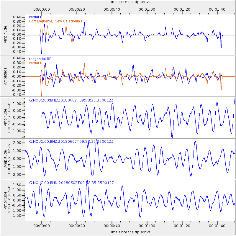
NOUC Port Laguerre, New Caledonia - Earthquake Result Viewer
*The percent match for this event was below the threshold and hence no stack was calculated.
| Earthquake location: |
East Of Kuril Islands |
| Earthquake latitude/longitude: |
43.9/148.0 |
| Earthquake time(UTC): |
2018/06/02 (153) 09:48:08 GMT |
| Earthquake Depth: |
10 km |
| Earthquake Magnitude: |
5.5 Mww |
| Earthquake Catalog/Contributor: |
NEIC PDE/us |
|
| Network: |
G GEOSCOPE |
| Station: |
NOUC Port Laguerre, New Caledonia |
| Lat/Lon: |
22.10 S/166.30 E |
| Elevation: |
112 m |
|
| Distance: |
67.8 deg |
| Az: |
161.713 deg |
| Baz: |
345.854 deg |
| Ray Param: |
$rayparam |
*The percent match for this event was below the threshold and hence was not used in the summary stack. |
|
| Radial Match: |
63.08316 % |
| Radial Bump: |
400 |
| Transverse Match: |
52.62898 % |
| Transverse Bump: |
400 |
| SOD ConfigId: |
2709371 |
| Insert Time: |
2018-06-16 09:50:33.833 +0000 |
| GWidth: |
2.5 |
| Max Bumps: |
400 |
| Tol: |
0.001 |
|
Signal To Noise
| Channel | StoN | STA | LTA |
| G:NOUC:00:BHZ:20180602T09:58:35.350012Z | 2.1886392 | 1.2793054E-6 | 5.8452093E-7 |
| G:NOUC:00:BHN:20180602T09:58:35.350012Z | 2.994956 | 1.0515215E-6 | 3.5109747E-7 |
| G:NOUC:00:BHE:20180602T09:58:35.350012Z | 1.131119 | 4.7639833E-7 | 4.2117435E-7 |
| Arrivals |
| Ps | |
| PpPs | |
| PsPs/PpSs | |


