You are here: Home > Network List > GS - US Geological Survey Networks Stations List
> Station DEC06 Boomer > Earthquake Result Viewer
DEC06 Boomer - Earthquake Result Viewer
*The percent match for this event was below the threshold and hence no stack was calculated.
| Earthquake location: |
East Of Kuril Islands |
| Earthquake latitude/longitude: |
43.9/148.0 |
| Earthquake time(UTC): |
2018/06/02 (153) 09:48:08 GMT |
| Earthquake Depth: |
10 km |
| Earthquake Magnitude: |
5.5 Mww |
| Earthquake Catalog/Contributor: |
NEIC PDE/us |
|
| Network: |
GS US Geological Survey Networks |
| Station: |
DEC06 Boomer |
| Lat/Lon: |
39.90 N/88.95 W |
| Elevation: |
215 m |
|
| Distance: |
82.0 deg |
| Az: |
40.652 deg |
| Baz: |
322.29 deg |
| Ray Param: |
$rayparam |
*The percent match for this event was below the threshold and hence was not used in the summary stack. |
|
| Radial Match: |
74.76267 % |
| Radial Bump: |
400 |
| Transverse Match: |
58.619133 % |
| Transverse Bump: |
400 |
| SOD ConfigId: |
2709371 |
| Insert Time: |
2018-06-16 09:50:46.935 +0000 |
| GWidth: |
2.5 |
| Max Bumps: |
400 |
| Tol: |
0.001 |
|
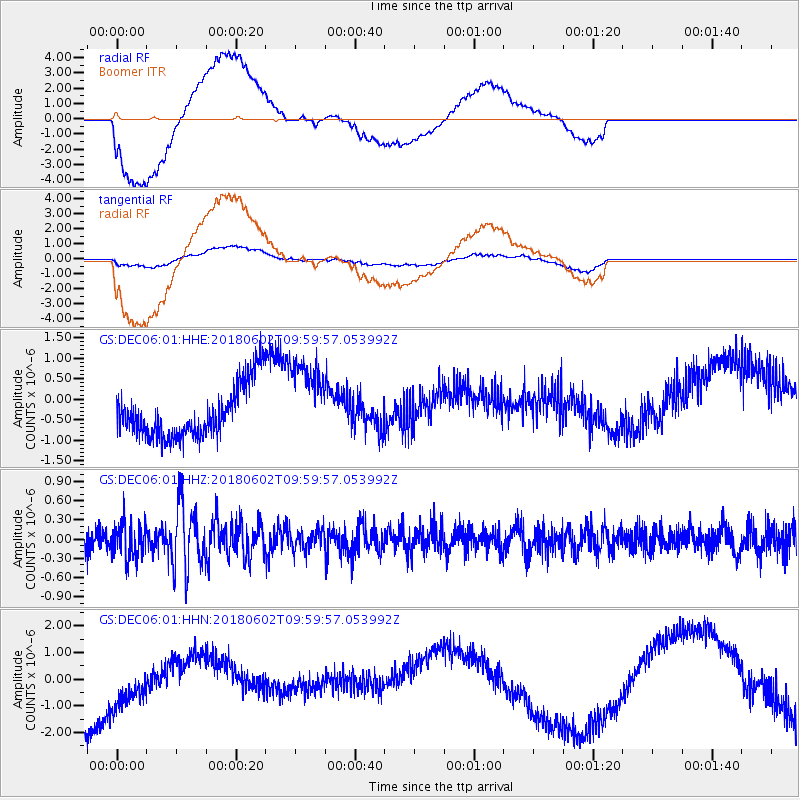
Signal To Noise
| Channel | StoN | STA | LTA |
| GS:DEC06:01:HHZ:20180602T09:59:57.053992Z | 1.7003446 | 2.8162214E-7 | 1.656265E-7 |
| GS:DEC06:01:HHN:20180602T09:59:57.053992Z | 1.0395136 | 9.706702E-7 | 9.3377344E-7 |
| GS:DEC06:01:HHE:20180602T09:59:57.053992Z | 1.6322141 | 1.0300712E-6 | 6.310883E-7 |
| Arrivals |
| Ps | |
| PpPs | |
| PsPs/PpSs | |


