You are here: Home > Network List > AV - Alaska Volcano Observatory Stations List
> Station MAPS Pakushin Southeast, Makushin Volcano, Alaska > Earthquake Result Viewer
MAPS Pakushin Southeast, Makushin Volcano, Alaska - Earthquake Result Viewer

| Earthquake location: |
Northern Molucca Sea |
| Earthquake latitude/longitude: |
2.1/126.6 |
| Earthquake time(UTC): |
2021/12/26 (360) 02:22:53 GMT |
| Earthquake Depth: |
26 km |
| Earthquake Magnitude: |
5.3 Mww |
| Earthquake Catalog/Contributor: |
NEIC PDE/us |
|
| Network: |
AV Alaska Volcano Observatory |
| Station: |
MAPS Pakushin Southeast, Makushin Volcano, Alaska |
| Lat/Lon: |
53.81 N/166.94 W |
| Elevation: |
333 m |
|
| Distance: |
74.5 deg |
| Az: |
34.336 deg |
| Baz: |
251.88 deg |
| Ray Param: |
0.05224583 |
| Estimated Moho Depth: |
11.0 km |
| Estimated Crust Vp/Vs: |
1.62 |
| Assumed Crust Vp: |
3.943 km/s |
| Estimated Crust Vs: |
2.434 km/s |
| Estimated Crust Poisson's Ratio: |
0.19 |
|
| Radial Match: |
93.78802 % |
| Radial Bump: |
256 |
| Transverse Match: |
93.42017 % |
| Transverse Bump: |
296 |
| SOD ConfigId: |
26694651 |
| Insert Time: |
2022-01-20 23:21:24.329 +0000 |
| GWidth: |
2.5 |
| Max Bumps: |
400 |
| Tol: |
0.001 |
|
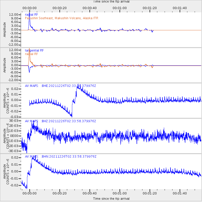
Signal To Noise
| Channel | StoN | STA | LTA |
| AV:MAPS: :BHZ:20211226T02:33:58.379976Z | 3.1198957 | 1.8541141E-9 | 5.9428723E-10 |
| AV:MAPS: :BHN:20211226T02:33:58.379976Z | 4.7121634 | 1.8496683E-8 | 3.925306E-9 |
| AV:MAPS: :BHE:20211226T02:33:58.379976Z | 4.8844 | 2.2349353E-8 | 4.5756603E-9 |
| Arrivals |
| Ps | 1.8 SECOND |
| PpPs | 7.2 SECOND |
| PsPs/PpSs | 9.0 SECOND |


