You are here: Home > Network List > TA - USArray Transportable Network (new EarthScope stations) Stations List
> Station TOLK Toolik Lake Research Station, AK, USA > Earthquake Result Viewer
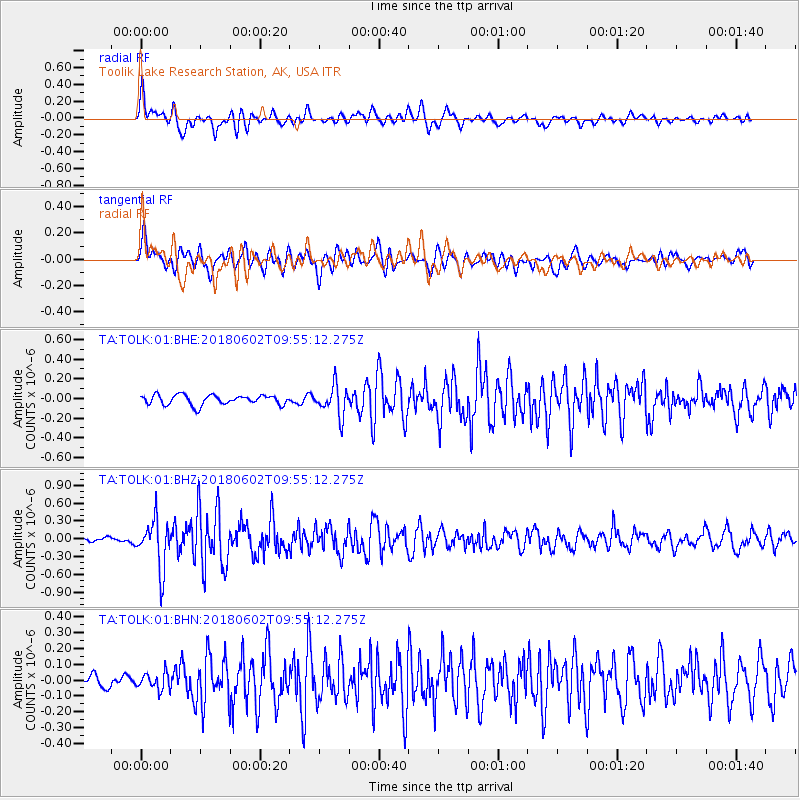
TOLK Toolik Lake Research Station, AK, USA - Earthquake Result Viewer
*The percent match for this event was below the threshold and hence no stack was calculated.
| Earthquake location: |
East Of Kuril Islands |
| Earthquake latitude/longitude: |
43.9/148.0 |
| Earthquake time(UTC): |
2018/06/02 (153) 09:48:08 GMT |
| Earthquake Depth: |
10 km |
| Earthquake Magnitude: |
5.5 Mww |
| Earthquake Catalog/Contributor: |
NEIC PDE/us |
|
| Network: |
TA USArray Transportable Network (new EarthScope stations) |
| Station: |
TOLK Toolik Lake Research Station, AK, USA |
| Lat/Lon: |
68.64 N/149.57 W |
| Elevation: |
760 m |
|
| Distance: |
40.0 deg |
| Az: |
30.337 deg |
| Baz: |
264.804 deg |
| Ray Param: |
$rayparam |
*The percent match for this event was below the threshold and hence was not used in the summary stack. |
|
| Radial Match: |
82.97009 % |
| Radial Bump: |
400 |
| Transverse Match: |
72.0307 % |
| Transverse Bump: |
400 |
| SOD ConfigId: |
2709371 |
| Insert Time: |
2018-06-16 09:54:29.133 +0000 |
| GWidth: |
2.5 |
| Max Bumps: |
400 |
| Tol: |
0.001 |
|
Signal To Noise
| Channel | StoN | STA | LTA |
| TA:TOLK:01:BHZ:20180602T09:55:12.275Z | 7.5299535 | 4.067393E-7 | 5.401618E-8 |
| TA:TOLK:01:BHN:20180602T09:55:12.275Z | 1.2230868 | 5.2580923E-8 | 4.2990344E-8 |
| TA:TOLK:01:BHE:20180602T09:55:12.275Z | 3.0579062 | 1.5192525E-7 | 4.968277E-8 |
| Arrivals |
| Ps | |
| PpPs | |
| PsPs/PpSs | |


