You are here: Home > Network List > AK - Alaska Regional Network Stations List
> Station D20K Etivluk River, AK, USA > Earthquake Result Viewer
D20K Etivluk River, AK, USA - Earthquake Result Viewer
| Earthquake location: |
Qinghai, China |
| Earthquake latitude/longitude: |
37.8/101.3 |
| Earthquake time(UTC): |
2022/01/07 (007) 17:45:30 GMT |
| Earthquake Depth: |
10 km |
| Earthquake Magnitude: |
6.6 mww |
| Earthquake Catalog/Contributor: |
NEIC PDE/us |
|
| Network: |
AK Alaska Regional Network |
| Station: |
D20K Etivluk River, AK, USA |
| Lat/Lon: |
68.71 N/156.61 W |
| Elevation: |
577 m |
|
| Distance: |
59.5 deg |
| Az: |
24.481 deg |
| Baz: |
295.996 deg |
| Ray Param: |
0.062154435 |
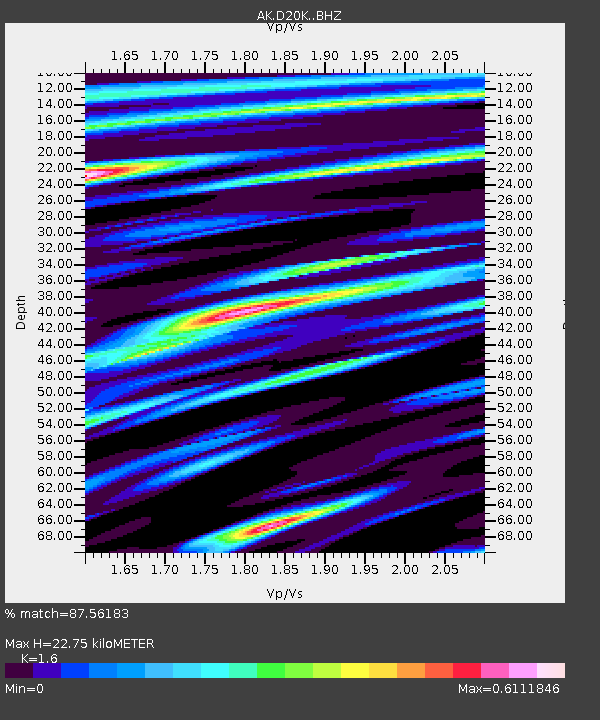
| Estimated Moho Depth: |
22.75 km |
| Estimated Crust Vp/Vs: |
1.60 |
| Assumed Crust Vp: |
6.221 km/s |
| Estimated Crust Vs: |
3.888 km/s |
| Estimated Crust Poisson's Ratio: |
0.18 |
|
| Radial Match: |
87.56183 % |
| Radial Bump: |
355 |
| Transverse Match: |
70.986694 % |
| Transverse Bump: |
400 |
| SOD ConfigId: |
26694651 |
| Insert Time: |
2022-01-21 17:48:03.244 +0000 |
| GWidth: |
2.5 |
| Max Bumps: |
400 |
| Tol: |
0.001 |
|

Signal To Noise
| Channel | StoN | STA | LTA |
| AK:D20K: :BHZ:20220107T17:55:02.200012Z | 17.686123 | 3.2424387E-6 | 1.8333238E-7 |
| AK:D20K: :BHN:20220107T17:55:02.200012Z | 1.1087794 | 2.4911066E-7 | 2.2467107E-7 |
| AK:D20K: :BHE:20220107T17:55:02.200012Z | 8.516078 | 1.3747464E-6 | 1.6142951E-7 |
| Arrivals |
| Ps | 2.3 SECOND |
| PpPs | 9.1 SECOND |
| PsPs/PpSs | 11 SECOND |


