You are here: Home > Network List > AK - Alaska Regional Network Stations List
> Station F21K Alatna River, AK, USA > Earthquake Result Viewer
F21K Alatna River, AK, USA - Earthquake Result Viewer
| Earthquake location: |
Qinghai, China |
| Earthquake latitude/longitude: |
37.8/101.3 |
| Earthquake time(UTC): |
2022/01/07 (007) 17:45:30 GMT |
| Earthquake Depth: |
10 km |
| Earthquake Magnitude: |
6.6 mww |
| Earthquake Catalog/Contributor: |
NEIC PDE/us |
|
| Network: |
AK Alaska Regional Network |
| Station: |
F21K Alatna River, AK, USA |
| Lat/Lon: |
67.22 N/153.48 W |
| Elevation: |
597 m |
|
| Distance: |
61.2 deg |
| Az: |
25.377 deg |
| Baz: |
299.338 deg |
| Ray Param: |
0.061010387 |
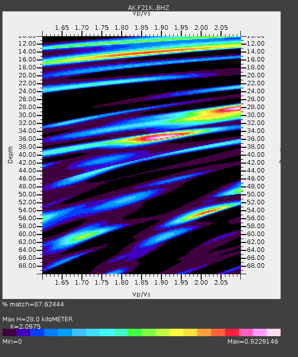
| Estimated Moho Depth: |
28.0 km |
| Estimated Crust Vp/Vs: |
2.10 |
| Assumed Crust Vp: |
6.455 km/s |
| Estimated Crust Vs: |
3.078 km/s |
| Estimated Crust Poisson's Ratio: |
0.35 |
|
| Radial Match: |
87.62444 % |
| Radial Bump: |
334 |
| Transverse Match: |
76.92113 % |
| Transverse Bump: |
400 |
| SOD ConfigId: |
26694651 |
| Insert Time: |
2022-01-21 17:48:22.106 +0000 |
| GWidth: |
2.5 |
| Max Bumps: |
400 |
| Tol: |
0.001 |
|

Signal To Noise
| Channel | StoN | STA | LTA |
| AK:F21K: :BHZ:20220107T17:55:14.080017Z | 10.165288 | 2.6414798E-6 | 2.5985292E-7 |
| AK:F21K: :BHN:20220107T17:55:14.080017Z | 1.7609951 | 5.026862E-7 | 2.8545577E-7 |
| AK:F21K: :BHE:20220107T17:55:14.080017Z | 5.4832973 | 1.089773E-6 | 1.9874412E-7 |
| Arrivals |
| Ps | 4.9 SECOND |
| PpPs | 13 SECOND |
| PsPs/PpSs | 18 SECOND |


