You are here: Home > Network List > US - United States National Seismic Network Stations List
> Station BOZ Bozeman, Montana, USA > Earthquake Result Viewer
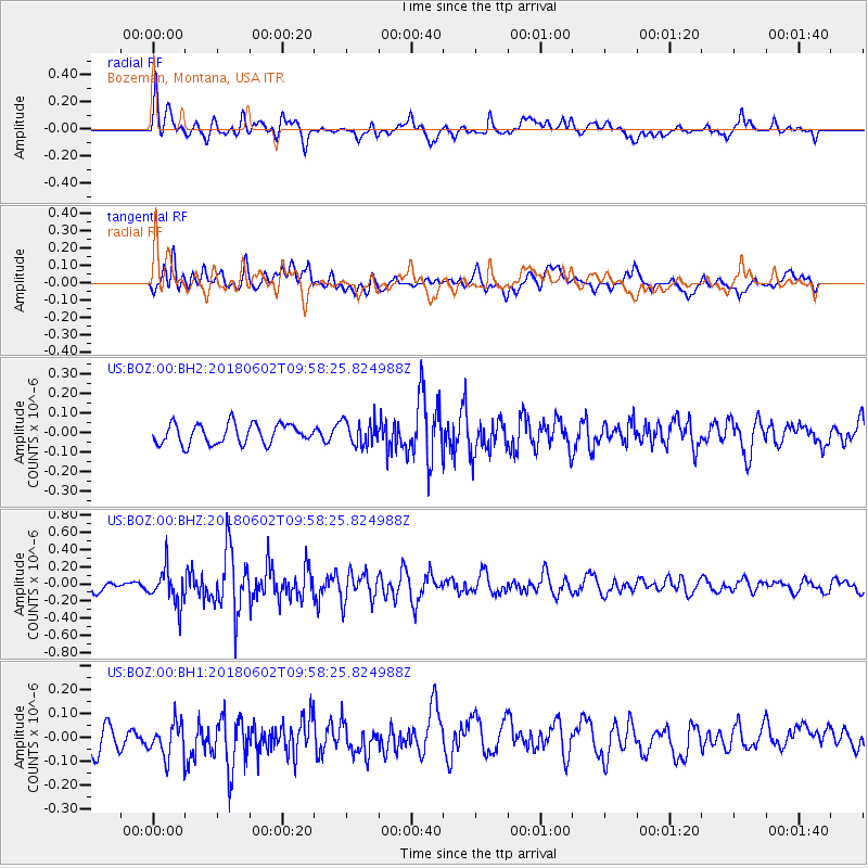
BOZ Bozeman, Montana, USA - Earthquake Result Viewer
*The percent match for this event was below the threshold and hence no stack was calculated.
| Earthquake location: |
East Of Kuril Islands |
| Earthquake latitude/longitude: |
43.9/148.0 |
| Earthquake time(UTC): |
2018/06/02 (153) 09:48:08 GMT |
| Earthquake Depth: |
10 km |
| Earthquake Magnitude: |
5.5 Mww |
| Earthquake Catalog/Contributor: |
NEIC PDE/us |
|
| Network: |
US United States National Seismic Network |
| Station: |
BOZ Bozeman, Montana, USA |
| Lat/Lon: |
45.65 N/111.63 W |
| Elevation: |
1589 m |
|
| Distance: |
66.3 deg |
| Az: |
48.913 deg |
| Baz: |
309.095 deg |
| Ray Param: |
$rayparam |
*The percent match for this event was below the threshold and hence was not used in the summary stack. |
|
| Radial Match: |
57.432217 % |
| Radial Bump: |
400 |
| Transverse Match: |
59.37146 % |
| Transverse Bump: |
400 |
| SOD ConfigId: |
2709371 |
| Insert Time: |
2018-06-16 09:55:55.852 +0000 |
| GWidth: |
2.5 |
| Max Bumps: |
400 |
| Tol: |
0.001 |
|
Signal To Noise
| Channel | StoN | STA | LTA |
| US:BOZ:00:BHZ:20180602T09:58:25.824988Z | 2.5225172 | 2.075827E-7 | 8.229188E-8 |
| US:BOZ:00:BH1:20180602T09:58:25.824988Z | 1.3460954 | 8.1301074E-8 | 6.03977E-8 |
| US:BOZ:00:BH2:20180602T09:58:25.824988Z | 1.2561916 | 6.4506445E-8 | 5.1350803E-8 |
| Arrivals |
| Ps | |
| PpPs | |
| PsPs/PpSs | |


