TUML YL.TUML - Earthquake Result Viewer
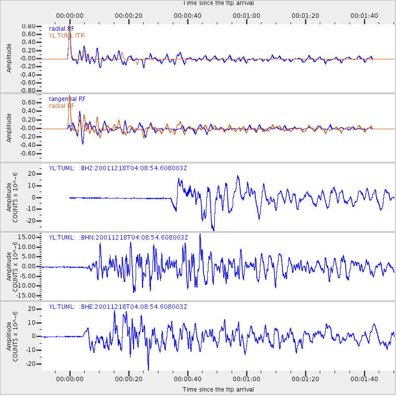
Earthquake location: Taiwan Region
Earthquake latitude/longitude: 24.0/122.7
Earthquake time(UTC): 2001/12/18 (352) 04:02:58 GMT
Earthquake Depth: 14 km
Earthquake Magnitude: 6.3 MB, 7.3 MS, 6.9 MW, 6.8 MW
Earthquake Catalog/Contributor: WHDF/NEIC
Network: YL Himalayan Nepal Tibet Experiment
Station: TUML YL.TUML
Lat/Lon: 27.32 N/87.19 E
Elevation: 360 m
Distance: 32.1 deg
Az: 283.63 deg
Baz: 87.919 deg
Ray Param: 0.078766525
Estimated Moho Depth: 42.0 km
Estimated Crust Vp/Vs: 1.69
Assumed Crust Vp: 6.236 km/s
Estimated Crust Vs: 3.69 km/s
Estimated Crust Poisson's Ratio: 0.23
Radial Match: 89.694534 %
Radial Bump: 400
Transverse Match: 87.754524 %
Transverse Bump: 400
SOD ConfigId: 16820
Insert Time: 2010-02-26 16:17:16.833 +0000
GWidth: 2.5
Max Bumps: 400
Tol: 0.001

Signal To Noise

ChannelStoNSTALTA
YL:TUML: :BHN:20011218T04:08:54.608003Z0.9029751.00420166E-71.1121035E-7
YL:TUML: :BHE:20011218T04:08:54.608003Z3.38251644.4149482E-71.305226E-7
YL:TUML: :BHZ:20011218T04:08:54.608003Z5.0701278.6251157E-71.7011637E-7
Arrivals
Ps5.0 SECOND
PpPs17 SECOND
PsPs/PpSs22 SECOND