You are here: Home > Network List > XE05 - Sierra Nevada EarthScope Project- EarthScope Flex Array Stations List
> Station SNP43 SNP43 > Earthquake Result Viewer
SNP43 SNP43 - Earthquake Result Viewer
| Earthquake location: |
Kuril Islands |
| Earthquake latitude/longitude: |
46.9/153.7 |
| Earthquake time(UTC): |
2006/11/15 (319) 11:33:23 GMT |
| Earthquake Depth: |
10 km |
| Earthquake Magnitude: |
5.5 MB |
| Earthquake Catalog/Contributor: |
WHDF/NEIC |
|
| Network: |
XE Sierra Nevada EarthScope Project- EarthScope Flex Array |
| Station: |
SNP43 SNP43 |
| Lat/Lon: |
37.41 N/119.48 W |
| Elevation: |
2274 m |
|
| Distance: |
61.9 deg |
| Az: |
64.297 deg |
| Baz: |
309.056 deg |
| Ray Param: |
0.060568266 |
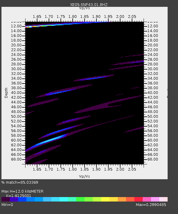
| Estimated Moho Depth: |
12.0 km |
| Estimated Crust Vp/Vs: |
1.61 |
| Assumed Crust Vp: |
6.291 km/s |
| Estimated Crust Vs: |
3.902 km/s |
| Estimated Crust Poisson's Ratio: |
0.19 |
|
| Radial Match: |
85.03369 % |
| Radial Bump: |
400 |
| Transverse Match: |
67.776085 % |
| Transverse Bump: |
400 |
| SOD ConfigId: |
268666 |
| Insert Time: |
2010-03-09 15:40:19.341 +0000 |
| GWidth: |
2.5 |
| Max Bumps: |
400 |
| Tol: |
0.001 |
|

Signal To Noise
| Channel | StoN | STA | LTA |
| XE:SNP43:01:BHZ:20061115T11:43:12.365002Z | 1.9202332 | 5.10699E-5 | 2.6595675E-5 |
| XE:SNP43:01:BHN:20061115T11:43:12.365002Z | 0.729821 | 2.2940463E-5 | 3.1433E-5 |
| XE:SNP43:01:BHE:20061115T11:43:12.365002Z | 0.6765117 | 2.418354E-5 | 3.574741E-5 |
| Arrivals |
| Ps | 1.2 SECOND |
| PpPs | 4.8 SECOND |
| PsPs/PpSs | 6.0 SECOND |


