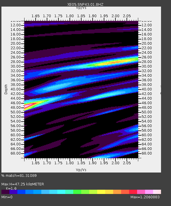
SNP43 SNP43 - Earthquake Result Viewer

Earthquake location: Tonga Islands
Earthquake latitude/longitude: -21.3/-174.7
Earthquake time(UTC): 2006/11/30 (334) 11:33:17 GMT
Earthquake Depth: 14 km
Earthquake Magnitude: 5.7 MB, 6.1 MS, 6.0 MW, 6.0 MW
Earthquake Catalog/Contributor: WHDF/NEIC
Network: XE Sierra Nevada EarthScope Project- EarthScope Flex Array
Station: SNP43 SNP43
Lat/Lon: 37.41 N/119.48 W
Elevation: 2274 m
Distance: 78.1 deg
Az: 41.914 deg
Baz: 231.477 deg
Ray Param: 0.04983296
Estimated Moho Depth: 47.25 km
Estimated Crust Vp/Vs: 1.60
Assumed Crust Vp: 6.291 km/s
Estimated Crust Vs: 3.932 km/s
Estimated Crust Poisson's Ratio: 0.18
Radial Match: 81.31089 %
Radial Bump: 400
Transverse Match: 46.563877 %
Transverse Bump: 400
SOD ConfigId: 268666
Insert Time: 2010-03-09 15:40:20.494 +0000
GWidth: 2.5
Max Bumps: 400
Tol: 0.001

Signal To Noise

ChannelStoNSTALTA
XE:SNP43:01:BHZ:20061130T11:44:44.340007Z4.6895675.56279E-71.1862054E-7
XE:SNP43:01:BHN:20061130T11:44:44.340007Z2.45335222.8301199E-71.1535726E-7
XE:SNP43:01:BHE:20061130T11:44:44.340007Z1.66702063.1300968E-71.8776593E-7
Arrivals
Ps4.7 SECOND
PpPs19 SECOND
PsPs/PpSs24 SECOND