You are here: Home > Network List > YL01 - Himalayan Nepal Tibet Experiment Stations List
> Station TUML YL.TUML > Earthquake Result Viewer
TUML YL.TUML - Earthquake Result Viewer

| Earthquake location: |
Eastern Honshu, Japan |
| Earthquake latitude/longitude: |
39.4/141.1 |
| Earthquake time(UTC): |
2001/12/02 (336) 13:01:53 GMT |
| Earthquake Depth: |
124 km |
| Earthquake Magnitude: |
6.1 MB, 6.5 MW, 6.5 MW |
| Earthquake Catalog/Contributor: |
WHDF/NEIC |
|
| Network: |
YL Himalayan Nepal Tibet Experiment |
| Station: |
TUML YL.TUML |
| Lat/Lon: |
27.32 N/87.19 E |
| Elevation: |
360 m |
|
| Distance: |
46.0 deg |
| Az: |
271.774 deg |
| Baz: |
60.509 deg |
| Ray Param: |
0.07050452 |
| Estimated Moho Depth: |
20.75 km |
| Estimated Crust Vp/Vs: |
1.83 |
| Assumed Crust Vp: |
6.236 km/s |
| Estimated Crust Vs: |
3.403 km/s |
| Estimated Crust Poisson's Ratio: |
0.29 |
|
| Radial Match: |
88.99582 % |
| Radial Bump: |
400 |
| Transverse Match: |
87.777885 % |
| Transverse Bump: |
400 |
| SOD ConfigId: |
16820 |
| Insert Time: |
2010-02-26 16:17:19.348 +0000 |
| GWidth: |
2.5 |
| Max Bumps: |
400 |
| Tol: |
0.001 |
|
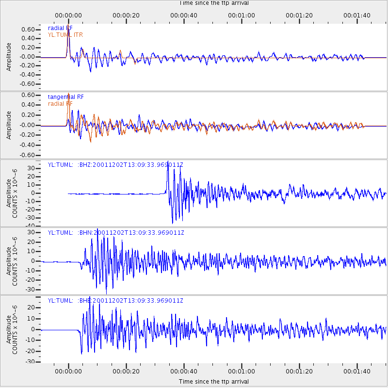
Signal To Noise
| Channel | StoN | STA | LTA |
| YL:TUML: :BHN:20011202T13:09:33.969011Z | 29.942953 | 2.0202353E-6 | 6.746948E-8 |
| YL:TUML: :BHE:20011202T13:09:33.969011Z | 53.537502 | 5.6601875E-6 | 1.05723785E-7 |
| YL:TUML: :BHZ:20011202T13:09:33.969011Z | 178.64671 | 1.0337533E-5 | 5.786579E-8 |
| Arrivals |
| Ps | 2.9 SECOND |
| PpPs | 8.9 SECOND |
| PsPs/PpSs | 12 SECOND |


