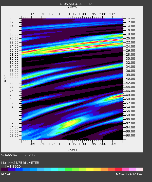
SNP43 SNP43 - Earthquake Result Viewer

Earthquake location: Azores Islands Region
Earthquake latitude/longitude: 37.3/-24.6
Earthquake time(UTC): 2007/04/05 (095) 03:56:50 GMT
Earthquake Depth: 14 km
Earthquake Magnitude: 6.1 MB, 6.2 MS, 6.3 MW, 6.2 MW
Earthquake Catalog/Contributor: WHDF/NEIC
Network: XE Sierra Nevada EarthScope Project- EarthScope Flex Array
Station: SNP43 SNP43
Lat/Lon: 37.41 N/119.48 W
Elevation: 2274 m
Distance: 71.9 deg
Az: 303.4 deg
Baz: 56.723 deg
Ray Param: 0.054035608
Estimated Moho Depth: 24.75 km
Estimated Crust Vp/Vs: 1.86
Assumed Crust Vp: 6.291 km/s
Estimated Crust Vs: 3.378 km/s
Estimated Crust Poisson's Ratio: 0.30
Radial Match: 86.698235 %
Radial Bump: 400
Transverse Match: 75.43972 %
Transverse Bump: 400
SOD ConfigId: 268666
Insert Time: 2010-03-09 15:40:35.003 +0000
GWidth: 2.5
Max Bumps: 400
Tol: 0.001

Signal To Noise

ChannelStoNSTALTA
XE:SNP43:01:BHZ:20070405T04:07:41.560017Z9.02386957.898094E-78.752448E-8
XE:SNP43:01:BHN:20070405T04:07:41.560017Z1.90011012.727221E-71.4352963E-7
XE:SNP43:01:BHE:20070405T04:07:41.560017Z1.99205232.788665E-71.3998955E-7
Arrivals
Ps3.5 SECOND
PpPs11 SECOND
PsPs/PpSs14 SECOND