You are here: Home > Network List > XE05 - Sierra Nevada EarthScope Project- EarthScope Flex Array Stations List
> Station SNP43 SNP43 > Earthquake Result Viewer
SNP43 SNP43 - Earthquake Result Viewer
| Earthquake location: |
Andreanof Islands, Aleutian Is. |
| Earthquake latitude/longitude: |
52.0/-180.0 |
| Earthquake time(UTC): |
2007/04/29 (119) 12:41:57 GMT |
| Earthquake Depth: |
117 km |
| Earthquake Magnitude: |
6.2 MB, 6.2 MW, 6.2 MW |
| Earthquake Catalog/Contributor: |
WHDF/NEIC |
|
| Network: |
XE Sierra Nevada EarthScope Project- EarthScope Flex Array |
| Station: |
SNP43 SNP43 |
| Lat/Lon: |
37.41 N/119.48 W |
| Elevation: |
2274 m |
|
| Distance: |
44.1 deg |
| Az: |
84.59 deg |
| Baz: |
309.389 deg |
| Ray Param: |
0.07171881 |
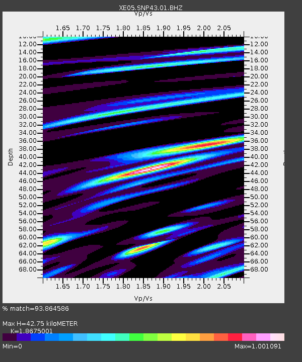
| Estimated Moho Depth: |
42.75 km |
| Estimated Crust Vp/Vs: |
1.87 |
| Assumed Crust Vp: |
6.291 km/s |
| Estimated Crust Vs: |
3.369 km/s |
| Estimated Crust Poisson's Ratio: |
0.30 |
|
| Radial Match: |
93.864586 % |
| Radial Bump: |
400 |
| Transverse Match: |
91.522484 % |
| Transverse Bump: |
400 |
| SOD ConfigId: |
268666 |
| Insert Time: |
2010-03-09 15:40:37.283 +0000 |
| GWidth: |
2.5 |
| Max Bumps: |
400 |
| Tol: |
0.001 |
|

Signal To Noise
| Channel | StoN | STA | LTA |
| XE:SNP43:01:BHZ:20070429T12:49:23.585007Z | 36.343384 | 9.70906E-6 | 2.6714793E-7 |
| XE:SNP43:01:BHN:20070429T12:49:23.585007Z | 21.262518 | 2.4558474E-6 | 1.15501244E-7 |
| XE:SNP43:01:BHE:20070429T12:49:23.585007Z | 25.396523 | 4.7907115E-6 | 1.8863652E-7 |
| Arrivals |
| Ps | 6.2 SECOND |
| PpPs | 18 SECOND |
| PsPs/PpSs | 25 SECOND |


