You are here: Home > Network List > XE05 - Sierra Nevada EarthScope Project- EarthScope Flex Array Stations List
> Station SNP43 SNP43 > Earthquake Result Viewer
SNP43 SNP43 - Earthquake Result Viewer
| Earthquake location: |
Fiji Islands Region |
| Earthquake latitude/longitude: |
-19.4/-179.4 |
| Earthquake time(UTC): |
2007/05/06 (126) 21:11:52 GMT |
| Earthquake Depth: |
676 km |
| Earthquake Magnitude: |
6.0 MB, 6.5 MW, 6.4 MW |
| Earthquake Catalog/Contributor: |
WHDF/NEIC |
|
| Network: |
XE Sierra Nevada EarthScope Project- EarthScope Flex Array |
| Station: |
SNP43 SNP43 |
| Lat/Lon: |
37.41 N/119.48 W |
| Elevation: |
2274 m |
|
| Distance: |
79.8 deg |
| Az: |
44.409 deg |
| Baz: |
236.052 deg |
| Ray Param: |
0.046551716 |
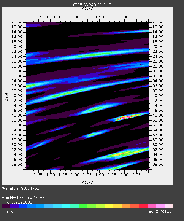
| Estimated Moho Depth: |
49.0 km |
| Estimated Crust Vp/Vs: |
1.98 |
| Assumed Crust Vp: |
6.291 km/s |
| Estimated Crust Vs: |
3.173 km/s |
| Estimated Crust Poisson's Ratio: |
0.33 |
|
| Radial Match: |
93.04751 % |
| Radial Bump: |
400 |
| Transverse Match: |
80.722244 % |
| Transverse Bump: |
400 |
| SOD ConfigId: |
268666 |
| Insert Time: |
2010-03-09 15:40:38.453 +0000 |
| GWidth: |
2.5 |
| Max Bumps: |
400 |
| Tol: |
0.001 |
|

Signal To Noise
| Channel | StoN | STA | LTA |
| XE:SNP43:01:BHZ:20070506T21:22:21.984009Z | 30.851784 | 3.8661296E-6 | 1.2531301E-7 |
| XE:SNP43:01:BHN:20070506T21:22:21.984009Z | 7.4725523 | 8.613499E-7 | 1.152685E-7 |
| XE:SNP43:01:BHE:20070506T21:22:21.984009Z | 14.252777 | 1.6108542E-6 | 1.1302038E-7 |
| Arrivals |
| Ps | 7.8 SECOND |
| PpPs | 23 SECOND |
| PsPs/PpSs | 31 SECOND |


