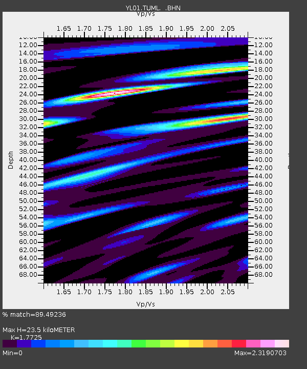
TUML YL.TUML - Earthquake Result Viewer

Earthquake location: Banda Sea
Earthquake latitude/longitude: -4.1/123.9
Earthquake time(UTC): 2001/10/19 (292) 03:28:44 GMT
Earthquake Depth: 33 km
Earthquake Magnitude: 6.3 MB, 7.3 MS, 7.5 MW, 7.4 MW
Earthquake Catalog/Contributor: WHDF/NEIC
Network: YL Himalayan Nepal Tibet Experiment
Station: TUML YL.TUML
Lat/Lon: 27.32 N/87.19 E
Elevation: 360 m
Distance: 47.2 deg
Az: 313.577 deg
Baz: 125.688 deg
Ray Param: 0.07005774
Estimated Moho Depth: 23.5 km
Estimated Crust Vp/Vs: 1.77
Assumed Crust Vp: 6.236 km/s
Estimated Crust Vs: 3.518 km/s
Estimated Crust Poisson's Ratio: 0.27
Radial Match: 89.49236 %
Radial Bump: 400
Transverse Match: 79.84895 %
Transverse Bump: 400
SOD ConfigId: 16820
Insert Time: 2010-02-26 16:17:23.176 +0000
GWidth: 2.5
Max Bumps: 400
Tol: 0.001

Signal To Noise

ChannelStoNSTALTA
YL:TUML: :BHN:20011019T03:36:43.724008Z3.49607064.049302E-71.1582438E-7
YL:TUML: :BHE:20011019T03:36:43.724008Z3.0411523.7582586E-71.235801E-7
YL:TUML: :BHZ:20011019T03:36:43.724008Z4.73433739.23453E-71.9505434E-7
Arrivals
Ps3.1 SECOND
PpPs9.9 SECOND
PsPs/PpSs13 SECOND