You are here: Home > Network List > AV - Alaska Volcano Observatory Stations List
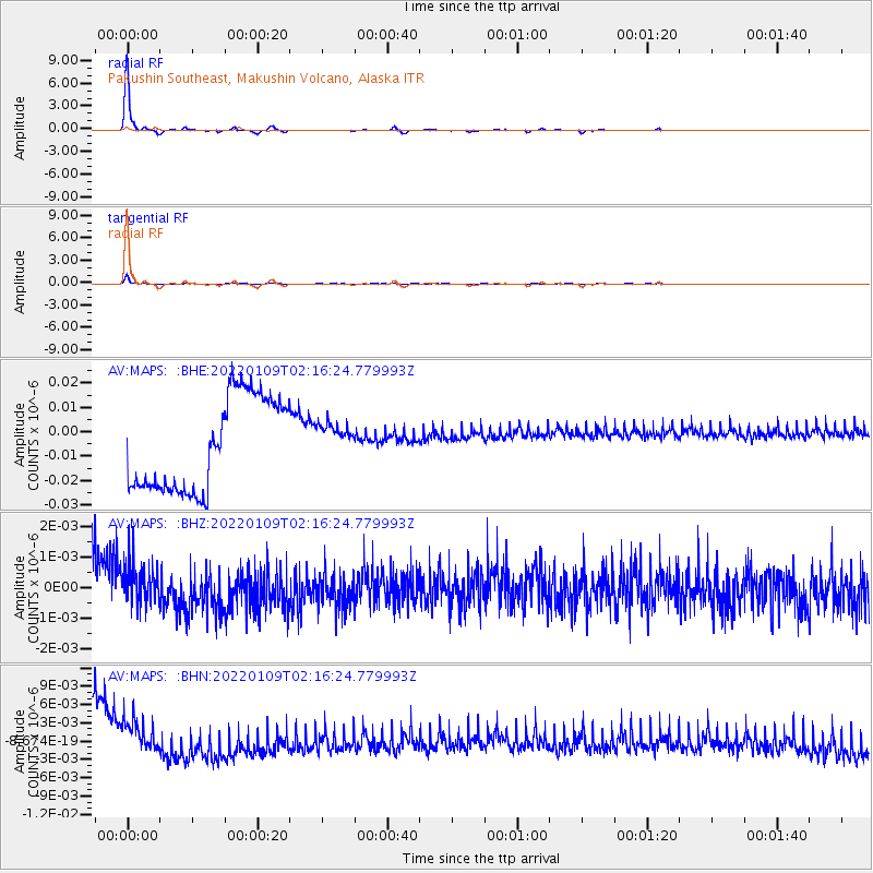
> Station MAPS Pakushin Southeast, Makushin Volcano, Alaska > Earthquake Result Viewer
MAPS Pakushin Southeast, Makushin Volcano, Alaska - Earthquake Result Viewer
| Earthquake location: |
New Britain Region, P.N.G. |
| Earthquake latitude/longitude: |
-7.2/152.6 |
| Earthquake time(UTC): |
2022/01/09 (009) 02:05:47 GMT |
| Earthquake Depth: |
20 km |
| Earthquake Magnitude: |
5.9 Mww |
| Earthquake Catalog/Contributor: |
NEIC PDE/us |
|
| Network: |
AV Alaska Volcano Observatory |
| Station: |
MAPS Pakushin Southeast, Makushin Volcano, Alaska |
| Lat/Lon: |
53.81 N/166.94 W |
| Elevation: |
333 m |
|
| Distance: |
69.7 deg |
| Az: |
24.244 deg |
| Baz: |
223.395 deg |
| Ray Param: |
0.055485096 |
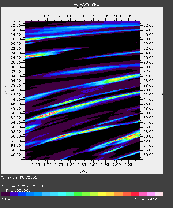
| Estimated Moho Depth: |
25.25 km |
| Estimated Crust Vp/Vs: |
1.60 |
| Assumed Crust Vp: |
3.943 km/s |
| Estimated Crust Vs: |
2.461 km/s |
| Estimated Crust Poisson's Ratio: |
0.18 |
|
| Radial Match: |
98.72006 % |
| Radial Bump: |
146 |
| Transverse Match: |
96.546555 % |
| Transverse Bump: |
277 |
| SOD ConfigId: |
26694651 |
| Insert Time: |
2022-01-23 02:11:56.476 +0000 |
| GWidth: |
2.5 |
| Max Bumps: |
400 |
| Tol: |
0.001 |
|
Signal To Noise
| Channel | StoN | STA | LTA |
| AV:MAPS: :BHZ:20220109T02:16:24.779993Z | 0.4021635 | 1.2601248E-9 | 3.1333642E-9 |
| AV:MAPS: :BHN:20220109T02:16:24.779993Z | 0.43663052 | 6.858257E-9 | 1.5707233E-8 |
| AV:MAPS: :BHE:20220109T02:16:24.779993Z | 0.404978 | 7.662201E-9 | 1.8920042E-8 |
| Arrivals |
| Ps | 3.9 SECOND |
| PpPs | 16 SECOND |
| PsPs/PpSs | 20 SECOND |


