You are here: Home > Network List > AU - Australian Seismological Centre Stations List
> Station WB2 Warramunga Array, Australia > Earthquake Result Viewer
WB2 Warramunga Array, Australia - Earthquake Result Viewer
| Earthquake location: |
South Of Kermadec Islands |
| Earthquake latitude/longitude: |
-33.8/179.5 |
| Earthquake time(UTC): |
2022/01/10 (010) 00:06:31 GMT |
| Earthquake Depth: |
10 km |
| Earthquake Magnitude: |
5.7 mww |
| Earthquake Catalog/Contributor: |
NEIC PDE/us |
|
| Network: |
AU Australian Seismological Centre |
| Station: |
WB2 Warramunga Array, Australia |
| Lat/Lon: |
19.94 S/134.35 E |
| Elevation: |
388 m |
|
| Distance: |
42.3 deg |
| Az: |
277.219 deg |
| Baz: |
118.566 deg |
| Ray Param: |
0.07327293 |
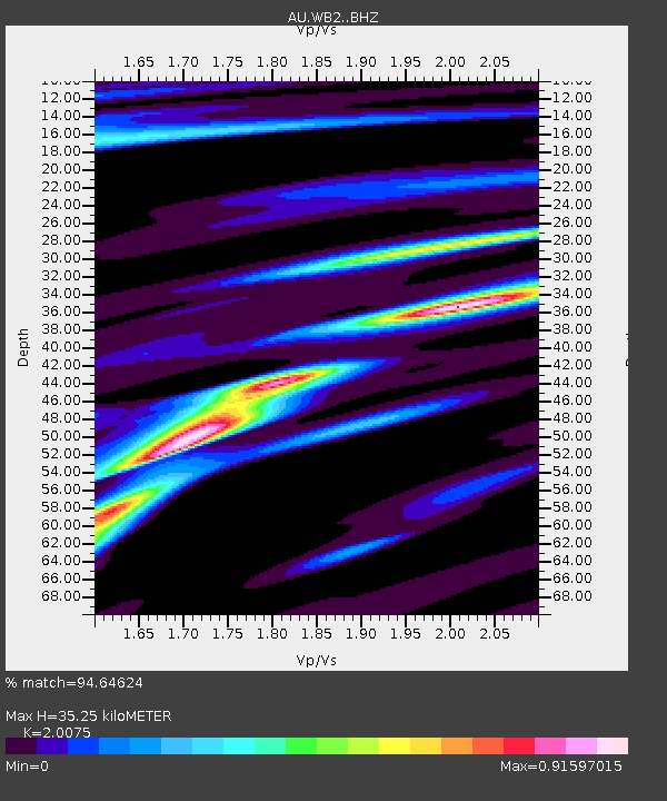
| Estimated Moho Depth: |
35.25 km |
| Estimated Crust Vp/Vs: |
2.01 |
| Assumed Crust Vp: |
6.642 km/s |
| Estimated Crust Vs: |
3.309 km/s |
| Estimated Crust Poisson's Ratio: |
0.33 |
|
| Radial Match: |
94.64624 % |
| Radial Bump: |
271 |
| Transverse Match: |
85.40178 % |
| Transverse Bump: |
400 |
| SOD ConfigId: |
26694651 |
| Insert Time: |
2022-01-24 00:09:31.508 +0000 |
| GWidth: |
2.5 |
| Max Bumps: |
400 |
| Tol: |
0.001 |
|

Signal To Noise
| Channel | StoN | STA | LTA |
| AU:WB2: :BHZ:20220110T00:13:53.975007Z | 10.433306 | 1.1963654E-6 | 1.1466791E-7 |
| AU:WB2: :BHN:20220110T00:13:53.975007Z | 2.6348984 | 3.308823E-7 | 1.2557686E-7 |
| AU:WB2: :BHE:20220110T00:13:53.975007Z | 4.5184975 | 5.602827E-7 | 1.2399755E-7 |
| Arrivals |
| Ps | 5.7 SECOND |
| PpPs | 15 SECOND |
| PsPs/PpSs | 21 SECOND |


