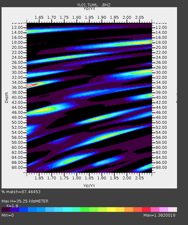
TUML YL.TUML - Earthquake Result Viewer
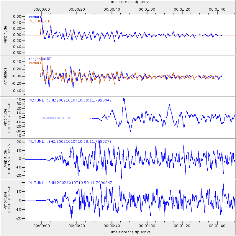
Earthquake location: Irian Jaya Region, Indonesia
Earthquake latitude/longitude: -1.8/134.3
Earthquake time(UTC): 2002/10/10 (283) 10:50:20 GMT
Earthquake Depth: 10 km
Earthquake Magnitude: 6.5 MB, 7.7 MS, 7.6 MW, 7.4 MW
Earthquake Catalog/Contributor: WHDF/NEIC
Network: YL Himalayan Nepal Tibet Experiment
Station: TUML YL.TUML
Lat/Lon: 27.32 N/87.19 E
Elevation: 360 m
Distance: 53.7 deg
Az: 306.071 deg
Baz: 114.76 deg
Ray Param: 0.06589658
Estimated Moho Depth: 35.25 km
Estimated Crust Vp/Vs: 1.60
Assumed Crust Vp: 6.236 km/s
Estimated Crust Vs: 3.897 km/s
Estimated Crust Poisson's Ratio: 0.18
Radial Match: 87.46453 %
Radial Bump: 400
Transverse Match: 82.06742 %
Transverse Bump: 400
SOD ConfigId: 16820
Insert Time: 2010-02-26 16:17:27.678 +0000
GWidth: 2.5
Max Bumps: 400
Tol: 0.001

Signal To Noise

ChannelStoNSTALTA
YL:TUML: :BHZ:20021010T10:59:11.798027Z7.9693485.9934564E-77.520636E-8
YL:TUML: :BHN:20021010T10:59:11.799004Z10.4853649.612554E-79.1675915E-8
YL:TUML: :BHE:20021010T10:59:11.799004Z14.1132672.234628E-61.5833528E-7
Arrivals
Ps3.6 SECOND
PpPs14 SECOND
PsPs/PpSs17 SECOND