You are here: Home > Network List > AV - Alaska Volcano Observatory Stations List
> Station KJL Kejulik, Katmai, Alaska > Earthquake Result Viewer
KJL Kejulik, Katmai, Alaska - Earthquake Result Viewer

| Earthquake location: |
South Of Kermadec Islands |
| Earthquake latitude/longitude: |
-33.8/179.5 |
| Earthquake time(UTC): |
2022/01/10 (010) 00:06:31 GMT |
| Earthquake Depth: |
10 km |
| Earthquake Magnitude: |
5.7 mww |
| Earthquake Catalog/Contributor: |
NEIC PDE/us |
|
| Network: |
AV Alaska Volcano Observatory |
| Station: |
KJL Kejulik, Katmai, Alaska |
| Lat/Lon: |
58.05 N/155.58 W |
| Elevation: |
792 m |
|
| Distance: |
93.8 deg |
| Az: |
12.954 deg |
| Baz: |
200.558 deg |
| Ray Param: |
0.04118018 |
| Estimated Moho Depth: |
69.75 km |
| Estimated Crust Vp/Vs: |
1.98 |
| Assumed Crust Vp: |
6.438 km/s |
| Estimated Crust Vs: |
3.252 km/s |
| Estimated Crust Poisson's Ratio: |
0.33 |
|
| Radial Match: |
80.68607 % |
| Radial Bump: |
400 |
| Transverse Match: |
79.093544 % |
| Transverse Bump: |
400 |
| SOD ConfigId: |
26694651 |
| Insert Time: |
2022-01-24 00:10:23.959 +0000 |
| GWidth: |
2.5 |
| Max Bumps: |
400 |
| Tol: |
0.001 |
|
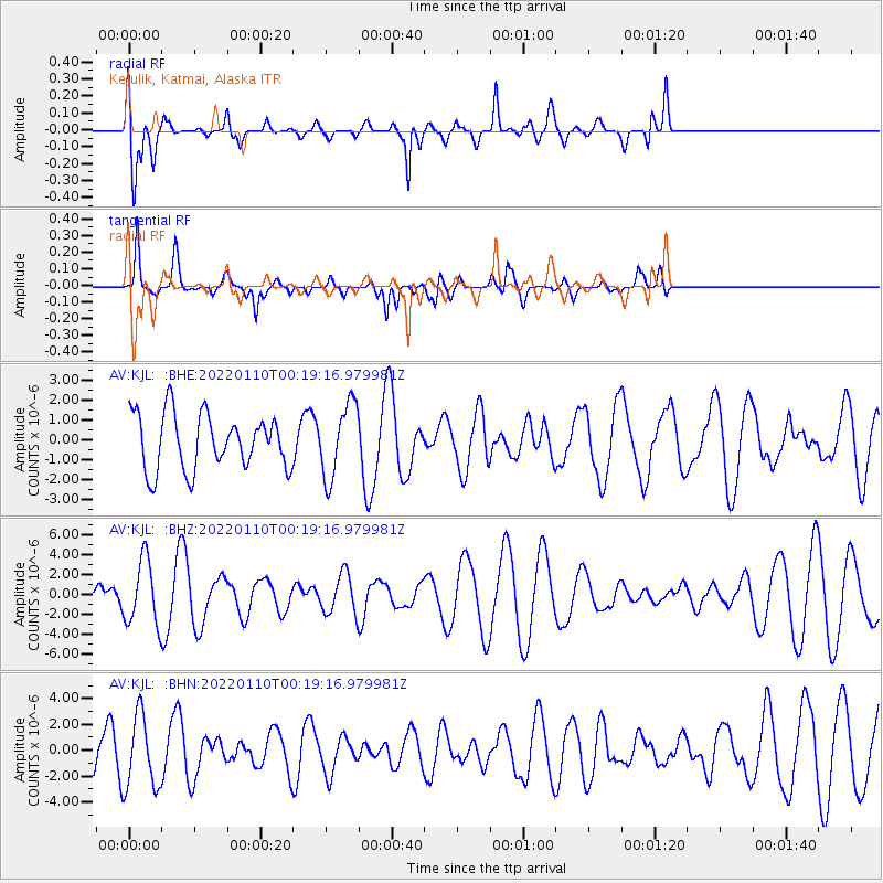
Signal To Noise
| Channel | StoN | STA | LTA |
| AV:KJL: :BHZ:20220110T00:19:16.979981Z | 4.0672827 | 3.2533458E-6 | 7.998819E-7 |
| AV:KJL: :BHN:20220110T00:19:16.979981Z | 1.2373848 | 2.828863E-6 | 2.2861627E-6 |
| AV:KJL: :BHE:20220110T00:19:16.979981Z | 1.3366936 | 1.8506034E-6 | 1.3844634E-6 |
| Arrivals |
| Ps | 11 SECOND |
| PpPs | 32 SECOND |
| PsPs/PpSs | 43 SECOND |


