You are here: Home > Network List > S1 - Australian Seismometers in Schools Stations List
> Station AUMBR Murray Bridge High School > Earthquake Result Viewer
AUMBR Murray Bridge High School - Earthquake Result Viewer
| Earthquake location: |
South Of Kermadec Islands |
| Earthquake latitude/longitude: |
-33.8/179.5 |
| Earthquake time(UTC): |
2022/01/10 (010) 00:06:31 GMT |
| Earthquake Depth: |
10 km |
| Earthquake Magnitude: |
5.7 mww |
| Earthquake Catalog/Contributor: |
NEIC PDE/us |
|
| Network: |
S1 Australian Seismometers in Schools |
| Station: |
AUMBR Murray Bridge High School |
| Lat/Lon: |
35.13 S/139.29 E |
| Elevation: |
50 m |
|
| Distance: |
33.1 deg |
| Az: |
256.114 deg |
| Baz: |
99.446 deg |
| Ray Param: |
0.07837845 |
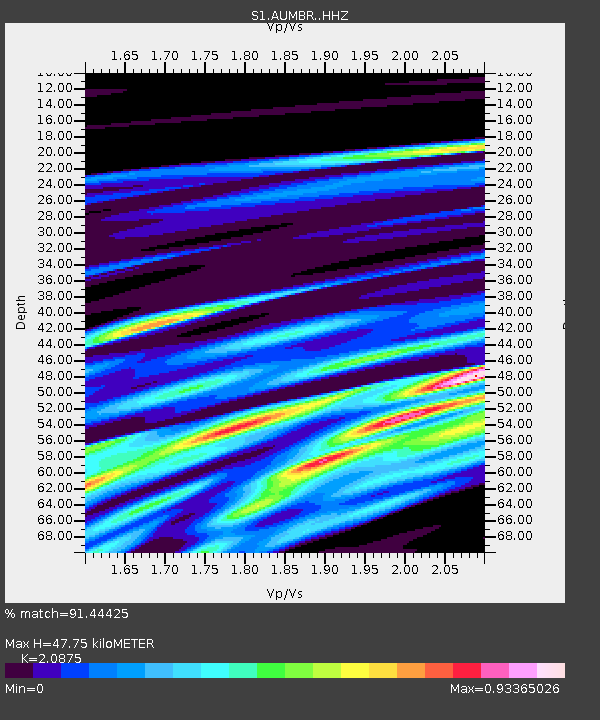
| Estimated Moho Depth: |
47.75 km |
| Estimated Crust Vp/Vs: |
2.09 |
| Assumed Crust Vp: |
6.576 km/s |
| Estimated Crust Vs: |
3.15 km/s |
| Estimated Crust Poisson's Ratio: |
0.35 |
|
| Radial Match: |
91.44425 % |
| Radial Bump: |
365 |
| Transverse Match: |
50.628105 % |
| Transverse Bump: |
384 |
| SOD ConfigId: |
26694651 |
| Insert Time: |
2022-01-24 00:19:00.463 +0000 |
| GWidth: |
2.5 |
| Max Bumps: |
400 |
| Tol: |
0.001 |
|

Signal To Noise
| Channel | StoN | STA | LTA |
| S1:AUMBR: :HHZ:20220110T00:12:36.209992Z | 3.2745655 | 1.9337263E-6 | 5.905291E-7 |
| S1:AUMBR: :HHN:20220110T00:12:36.209992Z | 1.7398043 | 9.662799E-7 | 5.5539573E-7 |
| S1:AUMBR: :HHE:20220110T00:12:36.209992Z | 2.3141408 | 1.1785888E-6 | 5.092987E-7 |
| Arrivals |
| Ps | 8.5 SECOND |
| PpPs | 21 SECOND |
| PsPs/PpSs | 29 SECOND |


