You are here: Home > Network List > XE05 - Sierra Nevada EarthScope Project- EarthScope Flex Array Stations List
> Station SNP44 SNP44 > Earthquake Result Viewer
SNP44 SNP44 - Earthquake Result Viewer
| Earthquake location: |
South Of Fiji Islands |
| Earthquake latitude/longitude: |
-23.6/-180.0 |
| Earthquake time(UTC): |
2006/02/26 (057) 03:08:27 GMT |
| Earthquake Depth: |
535 km |
| Earthquake Magnitude: |
5.9 MB, 6.4 MW, 6.4 MW |
| Earthquake Catalog/Contributor: |
WHDF/NEIC |
|
| Network: |
XE Sierra Nevada EarthScope Project- EarthScope Flex Array |
| Station: |
SNP44 SNP44 |
| Lat/Lon: |
37.50 N/119.28 W |
| Elevation: |
2070 m |
|
| Distance: |
83.4 deg |
| Az: |
44.292 deg |
| Baz: |
233.65 deg |
| Ray Param: |
0.044685848 |
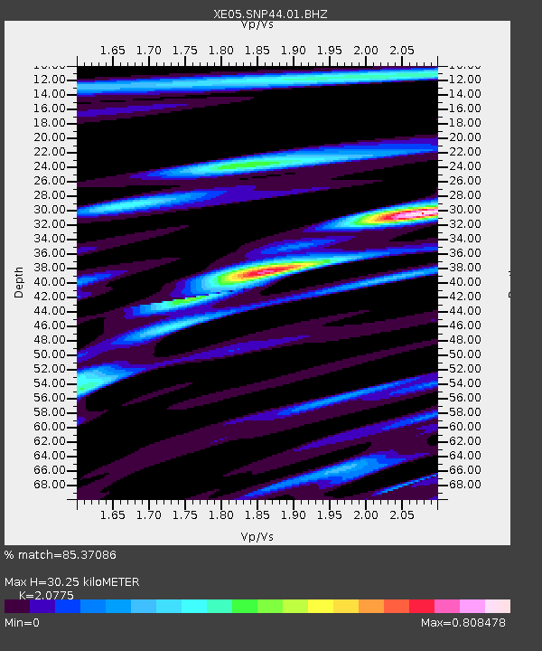
| Estimated Moho Depth: |
30.25 km |
| Estimated Crust Vp/Vs: |
2.08 |
| Assumed Crust Vp: |
6.291 km/s |
| Estimated Crust Vs: |
3.028 km/s |
| Estimated Crust Poisson's Ratio: |
0.35 |
|
| Radial Match: |
85.37086 % |
| Radial Bump: |
400 |
| Transverse Match: |
76.16834 % |
| Transverse Bump: |
400 |
| SOD ConfigId: |
268666 |
| Insert Time: |
2010-03-09 15:43:48.889 +0000 |
| GWidth: |
2.5 |
| Max Bumps: |
400 |
| Tol: |
0.001 |
|

Signal To Noise
| Channel | StoN | STA | LTA |
| XE:SNP44:01:BHZ:20060226T03:19:27.450015Z | 35.12148 | 2.849796E-6 | 8.114112E-8 |
| XE:SNP44:01:BHN:20060226T03:19:27.450015Z | 3.9203346 | 4.7504602E-7 | 1.2117486E-7 |
| XE:SNP44:01:BHE:20060226T03:19:27.450015Z | 6.289104 | 8.243596E-7 | 1.3107743E-7 |
| Arrivals |
| Ps | 5.3 SECOND |
| PpPs | 15 SECOND |
| PsPs/PpSs | 20 SECOND |


