You are here: Home > Network List > CI - Caltech Regional Seismic Network Stations List
> Station MUR Murrieta > Earthquake Result Viewer
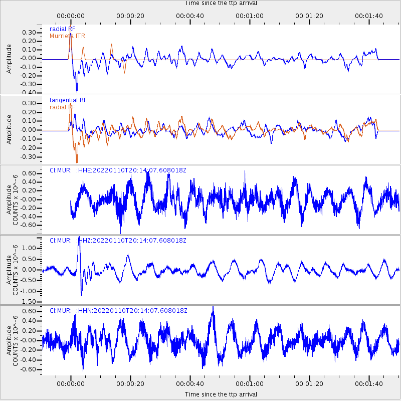
MUR Murrieta - Earthquake Result Viewer
*The percent match for this event was below the threshold and hence no stack was calculated.
| Earthquake location: |
South Of Fiji Islands |
| Earthquake latitude/longitude: |
-25.0/179.9 |
| Earthquake time(UTC): |
2022/01/10 (010) 20:03:03 GMT |
| Earthquake Depth: |
489 km |
| Earthquake Magnitude: |
5.7 Mww |
| Earthquake Catalog/Contributor: |
NEIC PDE/us |
|
| Network: |
CI Caltech Regional Seismic Network |
| Station: |
MUR Murrieta |
| Lat/Lon: |
33.60 N/117.20 W |
| Elevation: |
562 m |
|
| Distance: |
83.5 deg |
| Az: |
48.411 deg |
| Baz: |
234.402 deg |
| Ray Param: |
$rayparam |
*The percent match for this event was below the threshold and hence was not used in the summary stack. |
|
| Radial Match: |
48.701946 % |
| Radial Bump: |
400 |
| Transverse Match: |
44.821983 % |
| Transverse Bump: |
400 |
| SOD ConfigId: |
26694651 |
| Insert Time: |
2022-01-24 20:12:15.727 +0000 |
| GWidth: |
2.5 |
| Max Bumps: |
400 |
| Tol: |
0.001 |
|
Signal To Noise
| Channel | StoN | STA | LTA |
| CI:MUR: :HHZ:20220110T20:14:07.608018Z | 3.574766 | 6.15288E-7 | 1.721198E-7 |
| CI:MUR: :HHN:20220110T20:14:07.608018Z | 1.2224332 | 2.1670003E-7 | 1.7726941E-7 |
| CI:MUR: :HHE:20220110T20:14:07.608018Z | 1.1119527 | 2.6145915E-7 | 2.3513515E-7 |
| Arrivals |
| Ps | |
| PpPs | |
| PsPs/PpSs | |


