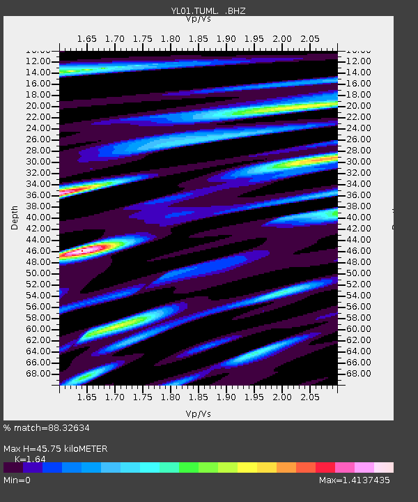
TUML YL.TUML - Earthquake Result Viewer
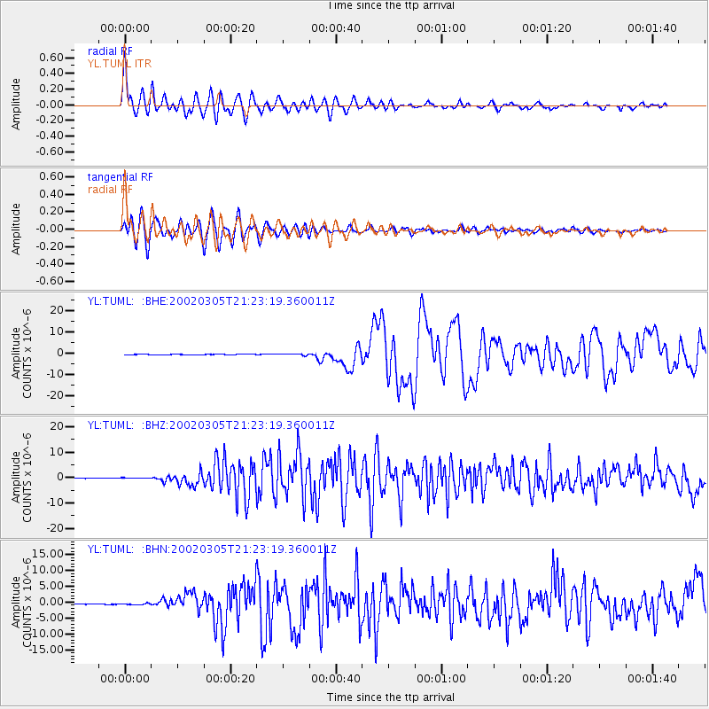
Earthquake location: Mindanao, Philippines
Earthquake latitude/longitude: 6.0/124.2
Earthquake time(UTC): 2002/03/05 (064) 21:16:09 GMT
Earthquake Depth: 31 km
Earthquake Magnitude: 6.3 MB, 7.2 MS, 7.5 MW, 7.2 MW
Earthquake Catalog/Contributor: WHDF/NEIC
Network: YL Himalayan Nepal Tibet Experiment
Station: TUML YL.TUML
Lat/Lon: 27.32 N/87.19 E
Elevation: 360 m
Distance: 41.1 deg
Az: 305.324 deg
Baz: 114.212 deg
Ray Param: 0.07395769
Estimated Moho Depth: 45.75 km
Estimated Crust Vp/Vs: 1.64
Assumed Crust Vp: 6.236 km/s
Estimated Crust Vs: 3.802 km/s
Estimated Crust Poisson's Ratio: 0.20
Radial Match: 88.32634 %
Radial Bump: 400
Transverse Match: 88.11557 %
Transverse Bump: 400
SOD ConfigId: 16820
Insert Time: 2010-02-26 16:17:44.548 +0000
GWidth: 2.5
Max Bumps: 400
Tol: 0.001

Signal To Noise

ChannelStoNSTALTA
YL:TUML: :BHZ:20020305T21:23:19.360011Z2.10043481.8545543E-78.829383E-8
YL:TUML: :BHN:20020305T21:23:19.360011Z3.2173661.6696757E-75.1895732E-8
YL:TUML: :BHE:20020305T21:23:19.360011Z3.44473983.29998E-79.579765E-8
Arrivals
Ps5.0 SECOND
PpPs18 SECOND
PsPs/PpSs23 SECOND