You are here: Home > Network List > US - United States National Seismic Network Stations List
> Station MNTX Cornudas Mountains, Texas, USA > Earthquake Result Viewer
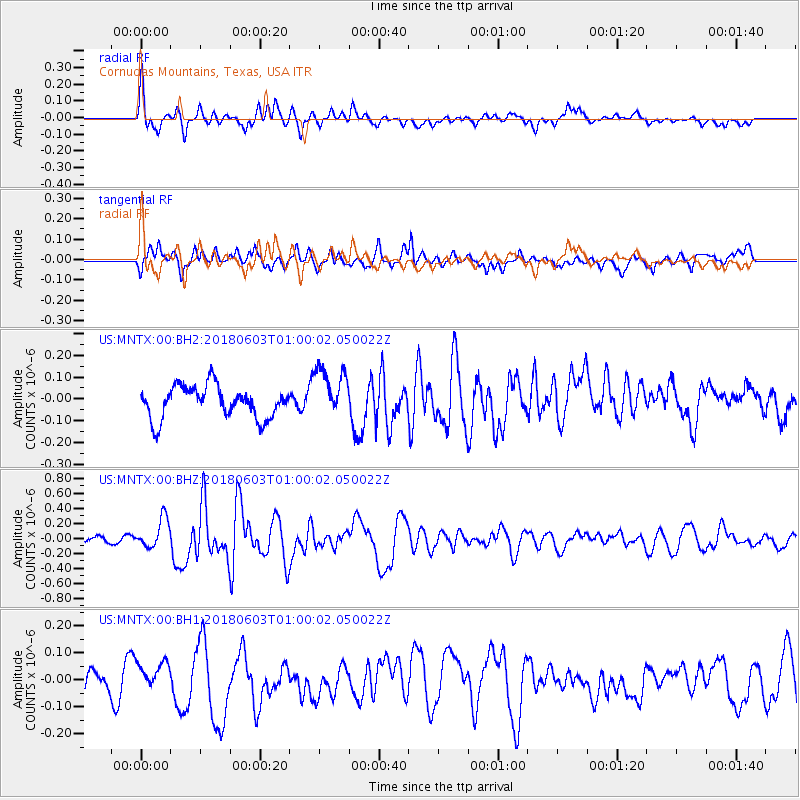
MNTX Cornudas Mountains, Texas, USA - Earthquake Result Viewer
*The percent match for this event was below the threshold and hence no stack was calculated.
| Earthquake location: |
Tonga Islands |
| Earthquake latitude/longitude: |
-19.4/-173.7 |
| Earthquake time(UTC): |
2018/06/03 (154) 00:48:09 GMT |
| Earthquake Depth: |
10 km |
| Earthquake Magnitude: |
5.6 mb |
| Earthquake Catalog/Contributor: |
NEIC PDE/us |
|
| Network: |
US United States National Seismic Network |
| Station: |
MNTX Cornudas Mountains, Texas, USA |
| Lat/Lon: |
31.70 N/105.38 W |
| Elevation: |
404 m |
|
| Distance: |
82.8 deg |
| Az: |
52.961 deg |
| Baz: |
242.118 deg |
| Ray Param: |
$rayparam |
*The percent match for this event was below the threshold and hence was not used in the summary stack. |
|
| Radial Match: |
57.19463 % |
| Radial Bump: |
382 |
| Transverse Match: |
67.269226 % |
| Transverse Bump: |
400 |
| SOD ConfigId: |
2709371 |
| Insert Time: |
2018-06-17 00:55:19.321 +0000 |
| GWidth: |
2.5 |
| Max Bumps: |
400 |
| Tol: |
0.001 |
|
Signal To Noise
| Channel | StoN | STA | LTA |
| US:MNTX:00:BHZ:20180603T01:00:02.050022Z | 4.67061 | 1.9658866E-7 | 4.2090573E-8 |
| US:MNTX:00:BH1:20180603T01:00:02.050022Z | 0.73669934 | 4.3390532E-8 | 5.889856E-8 |
| US:MNTX:00:BH2:20180603T01:00:02.050022Z | 1.645174 | 1.2025828E-7 | 7.30976E-8 |
| Arrivals |
| Ps | |
| PpPs | |
| PsPs/PpSs | |


