You are here: Home > Network List > YL01 - Himalayan Nepal Tibet Experiment Stations List
> Station TUML YL.TUML > Earthquake Result Viewer
TUML YL.TUML - Earthquake Result Viewer
| Earthquake location: |
Bonin Islands, Japan Region |
| Earthquake latitude/longitude: |
27.6/139.8 |
| Earthquake time(UTC): |
2002/06/03 (154) 09:15:00 GMT |
| Earthquake Depth: |
489 km |
| Earthquake Magnitude: |
5.0 MB, 5.9 MW, 5.9 MW |
| Earthquake Catalog/Contributor: |
WHDF/NEIC |
|
| Network: |
YL Himalayan Nepal Tibet Experiment |
| Station: |
TUML YL.TUML |
| Lat/Lon: |
27.32 N/87.19 E |
| Elevation: |
360 m |
|
| Distance: |
46.4 deg |
| Az: |
282.486 deg |
| Baz: |
76.962 deg |
| Ray Param: |
0.06844917 |
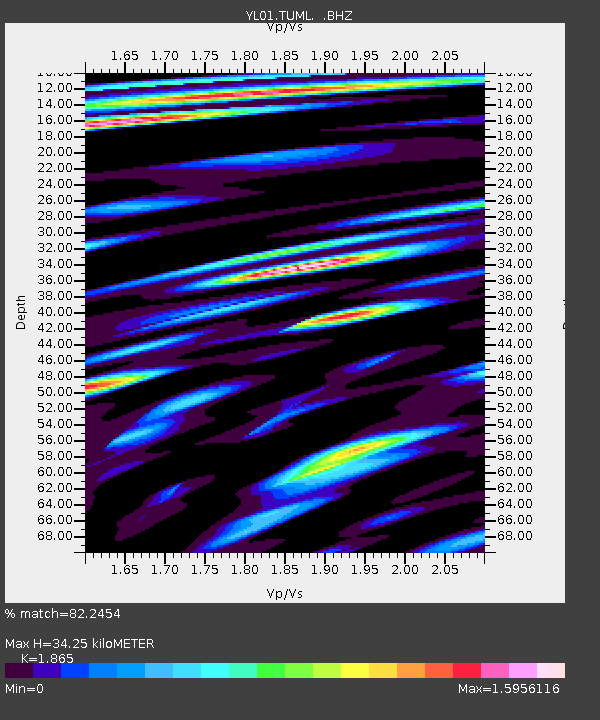
| Estimated Moho Depth: |
34.25 km |
| Estimated Crust Vp/Vs: |
1.87 |
| Assumed Crust Vp: |
6.236 km/s |
| Estimated Crust Vs: |
3.344 km/s |
| Estimated Crust Poisson's Ratio: |
0.30 |
|
| Radial Match: |
82.2454 % |
| Radial Bump: |
400 |
| Transverse Match: |
84.61104 % |
| Transverse Bump: |
400 |
| SOD ConfigId: |
16844 |
| Insert Time: |
2010-02-26 16:17:55.257 +0000 |
| GWidth: |
2.5 |
| Max Bumps: |
400 |
| Tol: |
0.001 |
|
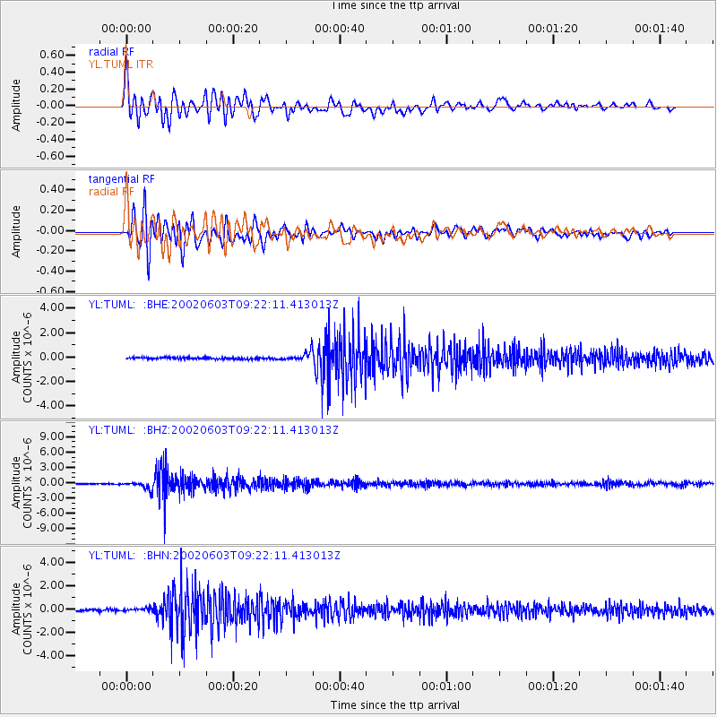
Signal To Noise
| Channel | StoN | STA | LTA |
| YL:TUML: :BHZ:20020603T09:22:11.413013Z | 9.464828 | 7.491537E-7 | 7.915133E-8 |
| YL:TUML: :BHN:20020603T09:22:11.413013Z | 2.0283139 | 1.4307787E-7 | 7.0540295E-8 |
| YL:TUML: :BHE:20020603T09:22:11.413013Z | 5.916783 | 3.9202033E-7 | 6.625566E-8 |
| Arrivals |
| Ps | 5.0 SECOND |
| PpPs | 15 SECOND |
| PsPs/PpSs | 20 SECOND |


