You are here: Home > Network List > UU - University of Utah Regional Network Stations List
> Station PKCU Pink Cliffs, UT, USA > Earthquake Result Viewer
PKCU Pink Cliffs, UT, USA - Earthquake Result Viewer
| Earthquake location: |
Tonga Islands |
| Earthquake latitude/longitude: |
-19.4/-173.7 |
| Earthquake time(UTC): |
2018/06/03 (154) 00:48:09 GMT |
| Earthquake Depth: |
10 km |
| Earthquake Magnitude: |
5.6 mb |
| Earthquake Catalog/Contributor: |
NEIC PDE/us |
|
| Network: |
UU University of Utah Regional Network |
| Station: |
PKCU Pink Cliffs, UT, USA |
| Lat/Lon: |
37.44 N/112.31 W |
| Elevation: |
2834 m |
|
| Distance: |
80.8 deg |
| Az: |
45.05 deg |
| Baz: |
237.067 deg |
| Ray Param: |
0.048036378 |
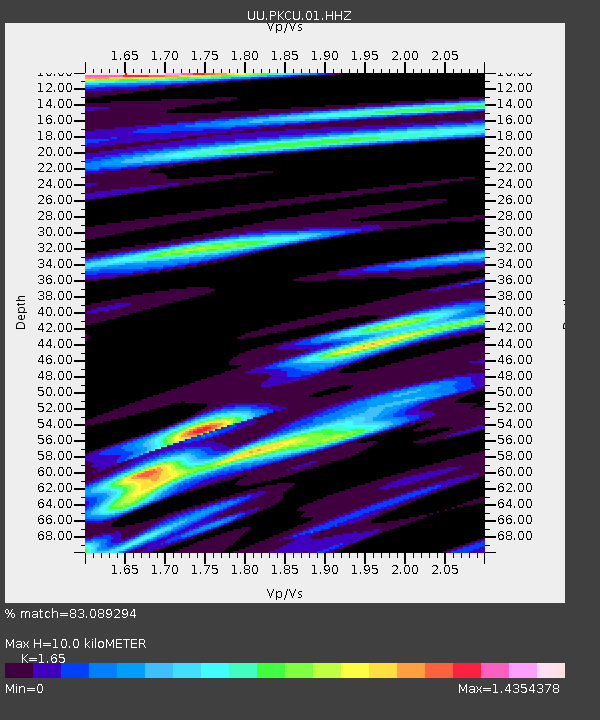
| Estimated Moho Depth: |
10.0 km |
| Estimated Crust Vp/Vs: |
1.65 |
| Assumed Crust Vp: |
6.194 km/s |
| Estimated Crust Vs: |
3.754 km/s |
| Estimated Crust Poisson's Ratio: |
0.21 |
|
| Radial Match: |
83.089294 % |
| Radial Bump: |
340 |
| Transverse Match: |
54.430363 % |
| Transverse Bump: |
400 |
| SOD ConfigId: |
2709371 |
| Insert Time: |
2018-06-17 00:56:06.126 +0000 |
| GWidth: |
2.5 |
| Max Bumps: |
400 |
| Tol: |
0.001 |
|

Signal To Noise
| Channel | StoN | STA | LTA |
| UU:PKCU:01:HHZ:20180603T00:59:51.35001Z | 2.6142159 | 7.693877E-9 | 2.9430915E-9 |
| UU:PKCU:01:HHN:20180603T00:59:51.35001Z | 1.3309568 | 6.1832077E-9 | 4.645686E-9 |
| UU:PKCU:01:HHE:20180603T00:59:51.35001Z | 0.971075 | 5.8417498E-9 | 6.0157554E-9 |
| Arrivals |
| Ps | 1.1 SECOND |
| PpPs | 4.2 SECOND |
| PsPs/PpSs | 5.2 SECOND |


