You are here: Home > Network List > TX - Texas Seismological Network Stations List
> Station FW15 Z > Earthquake Result Viewer
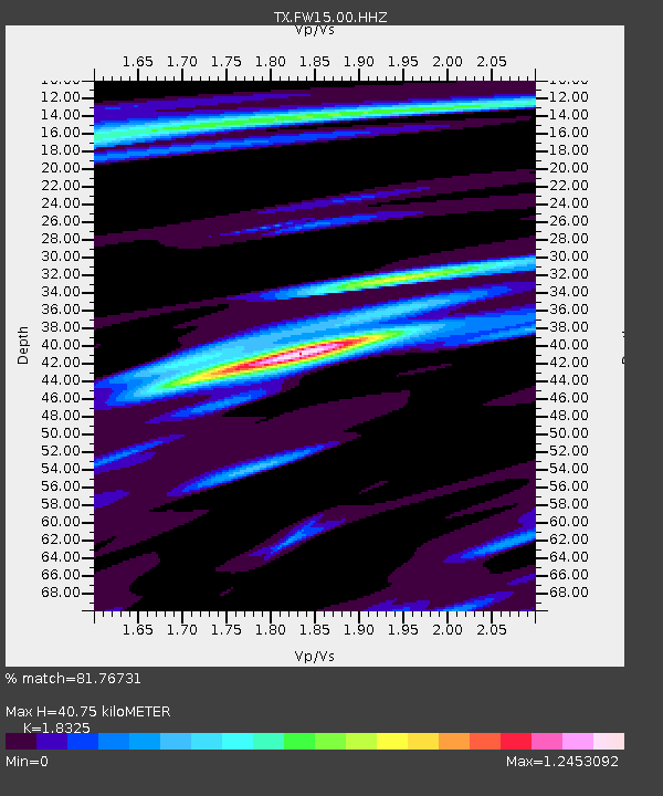
FW15 Z - Earthquake Result Viewer
| Earthquake location: |
Northern Mid-Atlantic Ridge |
| Earthquake latitude/longitude: |
28.5/-43.6 |
| Earthquake time(UTC): |
2022/01/10 (010) 23:26:45 GMT |
| Earthquake Depth: |
10 km |
| Earthquake Magnitude: |
5.8 Mww |
| Earthquake Catalog/Contributor: |
NEIC PDE/us |
|
| Network: |
TX Texas Seismological Network |
| Station: |
FW15 Z |
| Lat/Lon: |
32.70 N/97.37 W |
| Elevation: |
192 m |
|
| Distance: |
46.1 deg |
| Az: |
289.214 deg |
| Baz: |
80.412 deg |
| Ray Param: |
0.07089956 |
| Estimated Moho Depth: |
40.75 km |
| Estimated Crust Vp/Vs: |
1.83 |
| Assumed Crust Vp: |
6.38 km/s |
| Estimated Crust Vs: |
3.482 km/s |
| Estimated Crust Poisson's Ratio: |
0.29 |
|
| Radial Match: |
81.76731 % |
| Radial Bump: |
350 |
| Transverse Match: |
62.433887 % |
| Transverse Bump: |
400 |
| SOD ConfigId: |
26694651 |
| Insert Time: |
2022-01-24 23:53:46.100 +0000 |
| GWidth: |
2.5 |
| Max Bumps: |
400 |
| Tol: |
0.001 |
|

Signal To Noise
| Channel | StoN | STA | LTA |
| TX:FW15:00:HHZ:20220110T23:34:38.260015Z | 4.181448 | 1.1901288E-6 | 2.846212E-7 |
| TX:FW15:00:HH1:20220110T23:34:38.260015Z | 0.8855666 | 2.769034E-7 | 3.12685E-7 |
| TX:FW15:00:HH2:20220110T23:34:38.260015Z | 2.4713595 | 7.221888E-7 | 2.922233E-7 |
| Arrivals |
| Ps | 5.6 SECOND |
| PpPs | 17 SECOND |
| PsPs/PpSs | 23 SECOND |


